Rounding up the Olympic Games 2024 in Paris, a special focus is placed on the architectural language and phenomenon that transformed the city for its Olympic and upcoming Paralympic venues. Spread across the city and surrounding areas, Paris integrated iconic landmarks and modern facilities to host a diverse selection of Olympic sports. Beyond the sports venues, the interventions also included unique visitor centers and athlete's accommodations that will serve a purpose beyond the summer's events.
As the world witnesses an unprecedented exodus from rural to urban areas, cities face a monumental challenge: how to accommodate a constantly growing population? This phenomenon, characterized by rapid population growth and increasing density, puts pressure on resources, infrastructure, and urban services. As significant problems demand even larger solutions, it becomes necessary, more than ever, to rethink the tools at our disposal. In this challenging context, the rise of emerging technologies such as the Internet of Things (IoT), data analytics, and artificial intelligence (AI) presents itself as a light at the end of the tunnel. These technologies, initially conceived to simplify everyday tasks and facilitate communication, are potential instruments that enable an effective response to contemporary urban challenges.
Madrid, the vibrant capital of Spain, offers a blend of tradition and modernity, reflected in its diverse architectural heritage. This rich past is etched into the old façades, expansive public spaces, and historic religious institutions that define much of Madrid’s character today. The city’s continuous architectural renewal, reflected in both respectful restorations and innovative new constructions, highlights Madrid’s commitment to preserving its heritage while embracing modernity.
In the 20th century, Madrid embraced modernity, influenced by movements such as Rationalism, the International Style, and Brutalism. Today, Madrid is a showcase for contemporary design, where contemporary projects by renowned architects coexist with its historical legacy. Structures like the CaixaForum by Herzog & de Meuron and Jean Nouvel’s Reina Sofía Museum exemplify the city’s interest in architectural explorations
On October 23, 2023, during the closing of the Line Exhibition in Riyadh, Saudi Arabia, ArchDaily’s Editor in Chief, Christele Harrouk spoke to Tarek Qaddumi, Executive Director of The Line Design at NEOM, asking questions that probe into both the conceptual aspects and the technicalities of The Line project. In this video interview, the conversation addresses notions such as accessibility, transportation, and sustainability, while also exploring the concept of Cognitive Cities and the intended phasing of the project.
https://www.archdaily.com/1019840/building-the-line-as-a-three-dimensional-city-in-conversation-with-tarek-qaddumi-executive-director-of-the-line-design-of-neomArchDaily Team
In the first decades of the XXI century, Honduras experienced higher levels of crime and violence compared to its other Central American neighbors. This situation caused the country to be largely avoided by most visitors and investors. However, it didn’t stop Tegucigalpa, its capital city, from experiencing an explosion of residential and office developments which are currently reshaping its skyline. Defined by a unique topography, and tropical weather, the city served as a testing ground for modernist urban principles that contributed to the transformation of a small mining town into one of the largest metropolises in Central America.
To take advantage of the historic heritage of the city of Paris while also minimizing the impact of the Olympics, the Paris 2024 Games are organizing a set of temporary arenas and installations to host several key competitions, only to be disassembled after the games' closing. Only one sports venue has been built specifically for the 2024 Olympic Games, the Aquatics Centre Paris, as the city aims to use its existing sporting infrastructure to the maximum, ensuring a smaller footprint compared to previous editions. In addition to the established venues, key temporary sites include the Trocadéro, Eiffel Tower, Champ-de-Mars, Esplanade des Invalides, Pont Alexandre III, Place de la Concorde, and Place de l’Hôtel de Ville, with additional stands along the Seine for the Opening Ceremony.
The assembly and disassembly of these temporary sites will follow a step-by-step approach to minimize disruption. Geographical phasing will preserve traffic lanes and access to public spaces, while time phasing will gradually activate and deactivate competition perimeters to limit construction impact and quickly restore spaces post-Games. These measures align with Paris 2024's commitment to organizing responsible and respectful Games and preserving the city's urban and natural heritage.
Recent news headlines from the African continent show a variety of urgent issues affecting urban centers: severe flooding threatens Kenya's capital, Nairobi; the light rail system in Addis Ababa, Ethiopia, is faltering after a successful start. Meanwhile, in Egypt's capital, Cairo, new infrastructure and housing expenditures proved too steep and necessitated a government bailout. African cities face a plethora of problems but they also hold the potential to improve countless lives. As South America shares stark similarities in its history with that of Africa, it could provide both a point of reference and a positive example for tackling these concerns at an urban level.
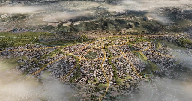
As part of a wider design-led revitalization process, Türkiye Design Council has announced a new urban plan for the revitalization of Antakya and the wider Hatay province in Türkiye, an area heavily affected by the Türkiye-Syria earthquake on 6 February 2023. The master plan has been developed by Foster + Partners, Buro Happold, MIC-HUB, along with Turkish practices DB Architects, and KEYM Urban Renewal Centre. The plan covers a 30-square-kilometer area of Antakya, the capital district of Hatay, and an important urban center of antiquity known as Antioch. Eight design principles have been outlined to guide the rebuilding efforts in an attempt to maintain the spirit of the city, which suffered extensive damages estimated at 80 percent.
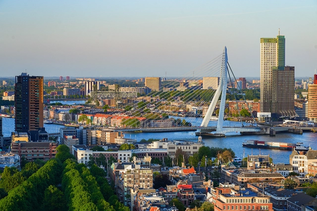
As we reach mid-2024, European cities showcase various urban development markers that are shaping the trajectory for the remainder of the year. Under themes of urban mobility in Brussels, sustainability in Valencia, Smart Cities in Rotterdam, and urban cooling in Paris, each city is making noteworthy progress on the road to meet the 2030 targets set by the Paris Agreement. In these diverse urban fabrics, European cities are committed to defining challenges and working towards shaping a climate-conscious future.
As major cities continue to develop, we face intriguing challenges regarding the preservation and adaptive reuse of significant buildings, sites, and artifacts. This poses a complex question that involves political history, architectural theory, and cultural significance. Adaptive reuse extends beyond architectural and spatial designs; it allows cities and communities to reflect, reevaluate, and reinterpret their history from different perspectives. However, unlike books and words, buildings may not withstand the test of time themselves and serve as firsthand evidence of the stories they tell. How should we question ourselves on what to preserve and demolish? How can communities be involved in the active restoration or adaptation of historic buildings?
New York City’s skyline tells the tale of the region’s dated relationship with architectural innovation and style. Among the many materials that cloak the city’s built environment, terracotta has a distinct significance. The clay-based material was a prominent feature in buildings from the late 1800s to the 1920s and, after a brief pause, is experiencing a resurgence with contemporary design. The revival pays homage to The Big Apple’s architectural heritage while leading a movement for sustainable materials in the city.
CityMakers, The Global Community of Architects Who Learn from Exemplary Cities and Their Makers, is working with ArchDaily to publish a series of articles about Barcelona, Medellin, and Rotterdam. The authors are the architects, urban planners, and/or strategists of the projects that have transformed these three cities, which are visited in the "Schools of Cities" and studied in the "Documentary-Courses" made by CityMakers. On this occasion, Alejandro Restrepo Montoya, Director of Urban Planning and Architecture of Medellín, presents his article "Environmental Urbanism and Urban Geographies, Medellín 2024-2027"
Medellín's urban plan focuses on answering how urban planning can improve people's quality of life. By developing its proposal, the city is promoting the social benefits that these urban planning practices can generate. Medellín emphasizes the use of natural and environmental conditions, such as valleys, streams, rivers, mountains, and hills, to develop urban planning criteria that address social needs.
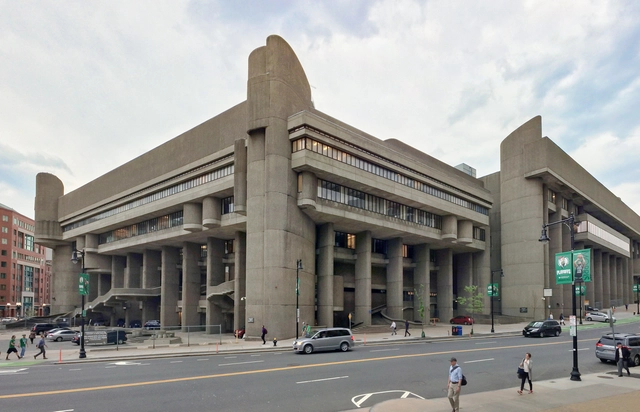
The Massachusetts administration, under Governor Maura Healey, has unveiled a new housing-centric proposal for the controversial Boston Government Service Center designed by Paul Rudolph and opened in 1971. Previously proposed to be redeveloped by the architecture office NBBJ with offices and commercial spaces, the updated vision aims to transform the Erich Lindemann and Charles F. Hurley buildings into housing facilities as part of the state’s goal to address the housing crisis while allowing for the historic preservation of the Brutalist structure.
Eastern and Southern Europe is enduring a severe heatwave, with temperatures reaching over 40 degrees Celsius in many countries including Greece, Croatia, Macedonia, and Romania. Driven by hot air from North Africa, this prolonged heatwave has raised significant threats for residents and has strained the cities’ mechanisms for protection and climate mitigation. As the heatwaves expose the vulnerabilities of urban infrastructures, cities across Europe are striving to implement measures to address these challenges.
The 2024 Paris Olympics, officially known as the XXXIII Olympiad is scheduled to take place from 26 July to 11 August 2024. The second city to host the Summer Olympics three times, after London, with the first in 1900 and later on in 1924, Paris will showcase its cultural heritage by hosting the 2024 games at iconic landmarks like the Grand Palais, Eiffel Tower, Gardens of Versailles, and La Concorde. On the other hand, the capital of France is also undergoing major renovations to its waterways with a billion-dollar 'Swimming Plan' aimed at transforming the Seine River into a swimmable aquatic route for the Olympic Games, seeking to restore its historical significance as a vibrant urban river.
With the Paris 2024 Olympics fast approaching and right around the corner, ArchDaily has curated a series of articles and news pieces providing comprehensive insights into both the built and unbuilt environments that will serve as hosts for the games.
URB has revealed details about the Dubai Green Spine project, an urban development initiative aiming to introduce a 64-kilometer-long green corridor in Dubai. The project, aligned with the Dubai 2040 Urban Master Plan, hopes to improve urban mobility and environmental quality by converting one of the city’s major arterial roads into a multifunctional public space with ample greenery, urban farms, integrated non-motorized transportation infrastructures, and community zones.
Prague, the capital of the Czech Republic, is one of Europe's best-preserved cities, having miraculously survived the widespread bombings of World War II. As the capital of the Czech Republic, Prague is home to over 1.3 million people and features an architectural heritage spanning centuries, covering a variety of architectural styles from Romanesque, Gothic, Renaissance, Baroque, and Rococo, to Modernist, Deconstructivism, and contemporary tendencies. The Old Town Square, where various architectural styles coexist, is a testament to this diversity. Known as the "Mother of all Cities," “the Golden City and “The City of a Hundred Spires,” Prague blends history and contemporary culture seamlessly. Its origins, steeped in legend, add to the city's charm.


. B. Estrada")


")
")
")
")


