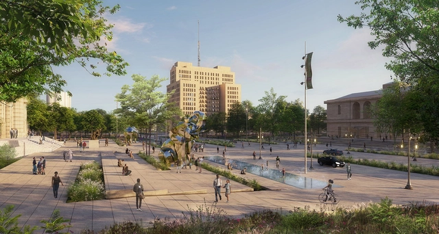
Woodward Avenue, between the Detroit Institute of Arts and the Detroit Public Library, serves as a public mediating ground on the nation's first paved road.. Image Courtesy of Agence Ter - Akoaki
The Detroit Cultural District has announced an ambitious initiative to reshape its urban landscape. This multi-phased project led by the Detroit Cultural Center Association (DCCA) in partnership with Design Leads Akoaki and Agence Ter, will transform the district's character, creating a more vibrant and accessible environment for residents and visitors alike. The project builds upon a comprehensive master plan, outlining a 15-year vision for the 80-acre campus in Detroit, Michigan. The plan's guiding principles focus on unifying the district's twelve institutions, improving pedestrian flow, and fostering a stronger sense of community.
Air rights transactions have become essential in urban development, allowing cities to grow vertically while preserving limited land resources. Typically defined as the right to use or sell the space above a property, air rights enable property owners to transfer unused floor area ratio (FAR) to neighboring parcels, creating increased density and financial gain opportunities. However, the definition can vary based on locality and region, as each country interprets air rights and the ability to build or transfer them differently. As urban centers face mounting pressures from limited land supply and population growth, air rights continue to offer a creative solution that fosters architectural innovation and economic efficiency.
The design of public bathrooms and changing facilities has historically catered to a generalized notion of user needs, often oversimplifying the complexities of gender-specific requirements and falling short of supporting the unique needs of women. These needs extend beyond biological differences—such as the necessity for more stall privacy and differences in height and body posture—to include cultural factors that influence restroom use and expectations over time.
For instance, women's contemporary clothing often lacks adequate pocket space, resulting in the need to carry a handbag, even for simple essentials like phones and wallets. Despite efforts in recent architectural designs to address these disparities, the layered nuances of biological, cultural, and gender identity factors present a multifaceted challenge that defies a one-size-fits-all solution.
THE LINE, Phase One Strategic Partners. Image Courtesy of NEOM
NEOM has announced the appointment of new partners to advance the city planning, design, and engineering for the initial phase of THE LINE, a core component of its region in northwest Saudi Arabia. The collaboration brings together Delugan Meissl Associate Architects (DMAA), Gensler, and Mott MacDonald, who will work alongside THE LINE's design and development teams to shape the urban landscape, offering expertise in urban design, planning consultancy, and infrastructure development.
In recent years, Public-Private Partnerships (PPPs) have become a significant model for delivering large-scale infrastructure projects around the world. These partnerships bring together the strengths of both the public sector, represented by governments or municipalities, and the private sector, combining their resources, expertise, and investment power. In the context of architecture and urban development, PPPs are increasingly being used to address the complex needs of growing cities, helping to finance, build, and maintain critical projects that would be difficult for either sector to accomplish alone. But what exactly are PPPs, and how do they function in the built environment? This article explores the concept of PPPs, providing examples from across the globe to illustrate how these partnerships are shaping the future of urban spaces, sometimes beyond commercial gains. Furthermore, by exploring the different projects, the article aims to develop a framework around PPPs' positive and negative potential impacts.
New York-based office Field Operations, renowned for their work on Seattle's waterfront and New York's High Line, along with Toronto's Brook McIlroy, have been tasked with transforming underutilized lands beneath the Gardiner Expressway in Toronto. The project was launched by The Bentway Conservancy, in partnership with the City of Toronto, and represents the second phase of the development aiming to revitalize underutilized spaces along the expressway. The initiative set out to transform three large traffic islands between Dan Leckie Way and Spadina Avenue into an 11,500-square-meter public space for recreation and community activities.
Rural environments are often difficult to define in administrative and professional contexts and carry notable biases and complexities. Population and density thresholds are the most common determinants for drawing administrative boundaries, yet other factors, such as infrastructure, employment, and services, contribute to the characterization of rural environments. In the United States, the Census Bureau defines rurality, not by its characteristics or resources, but by absences, as "any population, housing, or territory not in an urban area." For the design and planning community, it is important to define the future of rural environments, not through the metrics of urban resources or infrastructure, but to design a new framework for flexibility, adaptation, and health.
Traveling on land through vast regional areas of African countries has been an inefficient ordeal, particularly in West Africa. Google Maps optimistically estimates it would take 53 hours to drive nonstop from Lagos, Nigeria's largest city, to Dakar, Senegal's capital. However, this estimate doesn't account for the poor road infrastructure, complex border crossings, and socio-economic challenges that realistically extend the journey to about a week.
This is why the ongoing Trans-West African Coastal Highway project offers a great opportunity to connect and unlock the region's potential. This project, also known as TAH 7, is a transnational highway initiative linking 12 West African coastal nations, from Mauritania in the northwest to Nigeria in the east. Its gradual construction opens new avenues for freight movement, rail infrastructure, and, more importantly, innovative forms of architecture around borders, addressing their unique socio-cultural functions.
There is growing awareness of the importance of developing pedestrian infrastructure. Bridges and elevated structures enhance the quality of cities by connecting spaces and reducing distances. Their use benefits pedestrians and the thousands of cyclists seeking a more sustainable mode of transportation.
Pedestrian infrastructures, such as bridges, walkways, and widened sidewalks, not only promote sustainable mobility but also contribute to the revitalization of urban areas. Their design can transform underused spaces into active, safe, and accessible places for everyone, enhancing social cohesion and fostering community. By incorporating elements such as greenery, smart lighting, and urban furniture, these structures become more than just thoroughfares: they transform into meeting points and spaces for social interaction.
Large-scale infrastructure projects often aim to connect distant locations within urban areas, facilitating quicker transportation, logistics, and commercial activities along their routes. However, while these projects link distant destinations, their substantial physical presence can significantly affect local communities. This may result in the disconnection and disengagement of previously connected neighborhoods, the disruption of public spaces, and generally negative outdoor experiences caused by noise, pollution, and lack of attention and maintenance to these infrastructures.
Nevertheless, several successful built environment projects have re-integrated contentious infrastructure into the community through thoughtful design of outdoor spaces, with Paris' Coulée verte René-Dumont being one of the first examples and New York's High Line being one of the most prominent examples. The High Line demonstrates how well-conceived outdoor projects can address the alienation caused by extensive infrastructure, foster community reconnection, serve as cultural and economic hubs, and even spur further economic redevelopment, as in Hudson Yards.
As a result of the nation’s ardent aspirations for growth and development, the social, economic, and physical landscape of India has transformed. A significant portion of the region’s population is of working age and comprises a massive market size, making India a land of opportunity especially in the eyes of foreign investors.
Reflecting this context, multiple mega-cities and mega-projects characterize the built environment and push the nation toward superpower status. On the flip side of the coin, these visionary projects along with the trend of rapid urbanization also bring in a range of side effects - the spread of informal settlements and in turn, the challenges to equitable development.
CityMakers, The Global Community of Architects Who Learn from Exemplary Cities and Their Makers, is working with ArchDaily to publish a series of articles about Barcelona, Medellin, and Rotterdam. The authors are the architects, urban planners, and/or strategists of the projects that have transformed these three cities, which are visited in the "Schools of Cities" and studied in the "Documentary-Courses" made by CityMakers. On this occasion, Alejandro Restrepo Montoya, Director of Urban Planning and Architecture of Medellín, presents his article "Environmental Urbanism and Urban Geographies, Medellín 2024-2027"
Medellín's urban plan focuses on answering how urban planning can improve people's quality of life. By developing its proposal, the city is promoting the social benefits that these urban planning practices can generate. Medellín emphasizes the use of natural and environmental conditions, such as valleys, streams, rivers, mountains, and hills, to develop urban planning criteria that address social needs.
The relentless drumbeat of climate disasters in the headlines—scorching heat waves, raging wildfires, historic floods, crippling droughts—are no longer a series of anomalies. As a grim new reality across much of the globe, these extreme weather events, driven by human-induced climate change, are becoming more frequent and severe. In short, they are clearly symptomatic of a broader and more pervasive environmental crisis.
Eastern and Southern Europe is enduring a severe heatwave, with temperatures reaching over 40 degrees Celsius in many countries including Greece, Croatia, Macedonia, and Romania. Driven by hot air from North Africa, this prolonged heatwave has raised significant threats for residents and has strained the cities’ mechanisms for protection and climate mitigation. As the heatwaves expose the vulnerabilities of urban infrastructures, cities across Europe are striving to implement measures to address these challenges.
Urban infrastructure intended for city connectivity disrupts urban patterns and often leaves behind a series of spaces without a properly defined use. Fortunately, the notion of space beneath infrastructure is being redefined, as architects are generating public spaces nestled under flyovers, bridges, and other urban structures.
Formerly neglected spaces, overlooked or dismissed as mere leftovers of urban planning, are now transformed into dynamic environments for community engagement and artistic expression. Architects, city planners, and the users themselves are embracing the challenge of reclaiming forgotten or underutilized areas and developing innovative solutions, integrating greenery, art installations, and sustainable elements into the urban fabric.
Following the collapse of the Francis Scott Key Bridge in Baltimore, Maryland, construction group WeBuild, in collaboration with design office CRA-Carlo Ratti Associati and engineer Michel Virlogeux, has revealed an updated design for a replacement bridge. The new cable-stayed design aims to redefine the entrance to the Baltimore Harbor and offer an improved version of this symbol of the city.
MASSLAB has just won the competition for the new roof of Bragança's Water Treatment Plant in Portugal. Integrating public use of this infrastructure, which until now only serves a functional purpose, the project showcases adding value to existing infrastructure by rethinking them. Blending architecture, landscaping, and urban design to transform this structure into a vibrant public space, MASSLAB seeks to change the perception of water treatment facilities in urban settings. By reimagining the roof as a livable infrastructure, the project transforms the purely functional roof into an engaging and integral part of the urban fabric.
Social infrastructure encompasses the resources and services that allow the creation of communal bonds and social connections. Within the built environment, it manifests through public spaces like parks, libraries, and community centers alongside threshold spaces such as public transportation stops.
These public social spaces play a crucial role in strengthening communities and, in turn, their ability to respond to catastrophic climate-related events. They can provide physical shelter to the populations most vulnerable to these events and foster resilient networks of people who can more quickly recover. Given the escalating frequency of extreme weather events in the United States due to climate change and its social infrastructure inadequacies, examining public spaces as a critical tool for climate resilience becomes vital.


. B. Estrada")