Tell the Water What the Clay Kept Secret. Image Courtesy of Ola Hassanain
Ola Hassanain is a Sudanese architect and artist operating in the Netherlands, and will be exhibiting at the Pan-African Architecture Biennale in Nairobi, Kenya, later in 2026. All three locations tell stories of the built environment's relationship with water. These illustrate the continuous battles between the amorphous forces of nature that are the rivers and seas, and human attempts to shape and control them. In most cases, they are attempts at extraction. Catastrophes happen as a result of the overreach of these attempts or of their mismanagement, or both.
For much of the twentieth century, architectural culture was shaped by the pursuit of lightness. Steel structures and curtain walls reduced the building envelope to a thin layer separating interior from exterior, while façades became smooth, continuous surfaces where windows were cut as precise openings within an abstract plane. But for centuries, buildings were conceived as bodies of mass; walls possessed depth, windows were recessed within thick masonry, and space was often experienced as something carved from the solidity of construction. In recent years, several contemporary projects appear to revisit this older spatial logic, reintroducing thickness as an architectural condition through deep openings, monolithic volumes, and heavy envelopes.
This shift does not imply a rejection of modern construction technologies, nor does it represent a nostalgic return to historical forms. Instead, it reflects a renewed interest in the fundamental relationship between material, mass, and void. By reintroducing thickness into the architectural vocabulary, these buildings reconnect contemporary practice with long-standing traditions in which space was inseparable from the weight and depth of construction.
As Europe experiences one of its earliest and most intense heatwaves in recent years, World Environment Day 2026 arrives amid renewed discussions about climate adaptation, urban resilience, and the capacity of cities to respond to increasingly extreme temperatures. Across Portugal, France, Italy, Spain, Germany, Switzerland, Ireland, and the United Kingdom, temperatures have surged well above seasonal averages, prompting heat alerts, school closures, emergency planning measures, and growing concerns about the performance of buildings and public infrastructure under prolonged heat stress. The convergence of these highlights a reality that is becoming increasingly worldwide: climate change is no longer solely an environmental concern but an issue that is fundamentally reshaping the spaces where people live, work, and gather.
Modern cities are running on performance indicators. They move millions of people each day, concentrate capital, separate land uses, and sustain complex systems of logistics and consumption. In that sense, the city functions as a system to be continually adjusted and optimized.
Today's dominant metrics are familiar and widely witnessed: vehicles per hour, average commute times, floor area ratios, parking turnover, housing starts, and tax revenue per parcel of land. These figures describe a city that is legible through efficiency. They are inherited from an industrial logic, where urban space is treated more like a production mechanism than a lived-in environment. In this framing, cities begin to mimic the needs and metrics of a machine.
Copenhagen, Denmark. Image Courtesy of Lindsay Martin via Unsplash
Copenhagen is long famous as the global capital of human-scale design and livability. Today, the city has widened its focus and is an active space where mid-century Scandinavian modernism meets the modern demands of climate adaptability, material circularity, radical conservation, and neighborhood density. During the first-ever Copenhagen Architecture Biennial, in 2025, the city transformed into a global platform for dialogue under the theme "Slow Down," exploring how architecture can respond to global pressures by rethinking the pace of change. And this year's 13th edition of the 3daysofdesign Festival will explore the theme of "Make This Moment Matter", encouraging the global design community to step away from digital noise and mass production to focus on the present.
Deep in western Honduras, within a valley near the Guatemalan border, lies the ancient Maya city of Copán. Flourishing during the Classic period between the fifth and ninth centuries CE, the city developed as a regional epicenter through trade networks, dynastic politics, and monumental architecture. Today, the site is designated a UNESCO World Heritage Site due to its extensive architectural remains, including stepped pyramids, sculpted stelae, and ceremonial core. Over a century of systematic archaeological research has documented its urban morphology, revealing distinct residential districts, civic spaces, and systems of movement and visibility.
This analysis examines the spatial organization of Copán through the framework of urban theorist Kevin Lynch and "The Image of the City". By applying Lynch's five structural elements — edges, districts, paths, nodes, and landmarks — it is possible to analyze how Copán functioned not only as a ritual center but as a legible urban landscape designed to reinforce political hierarchy and regulate collective movement. Historical data for this analysis was taken from books and articles linked throughout the text, and was possible thanks to the collaboration of historian Arnulfo Ramirez de la Costa, professor and coordinator of the History program in the Department of History at the National Autonomous University of Honduras (UNAH) in Tegucigalpa.
Located at the intersection of Adriatic landscapes and Balkan geopolitics, Tirana has undergone one of the most accelerated urban transformations in Europe over the last three decades. Once defined by rigid socialist planning and political isolation, the city has progressively reoriented itself through a combination of informal growth, international investment, and strategic urban interventions that seek to redefine its public image and spatial structure.
Since the early 2000s, a series of urban policies, most notably those initiated during the mayoral tenure of Edi Rama (now Albania prime minister), have promoted the use of color, public space, and architectural experimentation as tools for civic reactivation. Rather than relying solely on masterplans, Tirana's development has operated through interventions, where individual buildings and public spaces act as catalysts within a fragmented urban fabric.
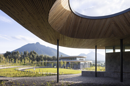
At the time of writing, an article by Martyn Evans asked 'Is Architecture in Crisis?' In the same year, Reinier de Graaf published the book 'Architecture Against Architecture,' where he set out fourteen problems with the profession and discipline. The question of a crisis in architecture is a perennial one. Referring to architecture as a profession, it rears its head especially when economic downturns are expected or in full swing. Simultaneously, there are ongoing questions regarding the effectiveness of architecture at dealing with the pressing matters of the globe and society—housing, climate change, and human development. One venture that attempts to address these questions is MASS, established in Rwanda not long after the 2008 financial crisis. The clue is in the name, which stands for Model of Architecture Serving Society. MASS was created as a different way of practicing architecture.
Recent years have seen a shifting paradigm in multi-family residential architecture, as more and more new projects are being built with engineered wood, specifically Cross-Laminated Timber (CLT) and glued-laminated timber (glulam). Because timber is lightweight, these systems can reduce dead load and ease foundation demands, which is especially useful on sites with limited bearing capacity or over existing infrastructure. From a sustainability standpoint, timber can store carbon over the life of the building and often reduces embodied carbon compared with conventional concrete-and-steel systems. In fire design, large timber members can be engineered to char at a predictable rate, allowing the structural core to remain protected for a defined period when detailed appropriately.
Architecture is often presented as the visible expression of its time, its desires, its faith in progress, its idea of order. Yet this reading tends to flatten the conditions under which buildings are produced. It suggests that architecture follows history when, in many cases, it actively participates in it. Few periods make this more evident than the twentieth century, when architecture became deeply entangled with political programs, economic systems, and competing visions of how collective life should be organized.
What is commonly grouped under the label of Modernism is often described as a coherent project, defined by formal clarity, technological optimism, and a break with historical styles. But this apparent coherence dissolves when we look beyond its canonical centres. The same spatial principles (standardization, functional zoning, industrial production) were adopted in political and economic contexts that differed significantly in their structures and objectives. A static movement unfolded as a flexible system continuously reoriented according to the priorities of each regime. What appeared as a shared language was, in practice, a set of tools applied to distinct agendas.
Cities in Southeastern Europe do not wait to be read. They accumulate, layer upon layer of socialist planning, post-socialist disruption, and the quieter, less legible work of citizens remaking space from the ground up. Here, space and legacy insist on their own terms. What happens to architectural research when the cities that we observe already seem to know something our discipline has not yet learned to see?
San Diego, California. Photo by Samuel Ramos on Unsplash
Very close to the Mexican border, in the southwest corner of the United States, lies the city of San Diego. Its urban history began in 1769 with the arrival of a Spanish military expedition commanded by Gaspar de Portola, which marked the first permanent settlement in the territory that was known as Alta California. However, unlike the more formally urbanized administrative capitals and towns of Mexico and Central America, San Diego was conceived as a frontier outpost. Today, it has become the second-largest city in California, just after Los Angeles, and its urban grid tells a story about the Hispanic heritage that is intertwined with the contemporary cultural environment of the United States.
In 2026, Apple marked fifty years since its founding. Over the past two decades, Apple has developed a consistent architectural language that extends its brand into the built environment, transforming stores, workplaces, and public-facing spaces into active components of its identity. These environments guide movement, frame interaction, and condition the ways in which users encounter both products and the company itself.
From the handheld device to the urban interior, Apple has sought to maintain a high degree of control over form, material, and experience. Architecture becomes part of this system when the company begins to define how it is perceived and engaged with in physical space. Research on retail environments has shown how spatial layout, visibility, and circulation patterns can shape behavior and interaction, turning architecture into an interface between brand and user.
Co-organized by UN-Habitat and the Government of Azerbaijan, the thirteenth session of the World Urban Forum 13 will take place in Baku from May 17 to 22, 2026, under the theme "Housing the World: Safe and Resilient Cities and Communities." Convened every two years by UN-Habitat, the World Urban Forum is considered one of the leading international conferences dedicated to urbanization and the future of cities. Bringing together architects, planners, policymakers, researchers, local governments, and civil society organizations, the forum serves as a platform for discussing the challenges shaping contemporary urban environments and the strategies needed to address them.
In Other Worlds Film still from Planet City (2021) by Liam Young. Image Courtesy of Liam Young
The Barbican Centre has announced In Other Worlds, a major immersive exhibition by speculative architect, filmmaker, and artist Liam Young, opening from May 21 through September 6, 2026. Occupying three distinct locations within the Barbican complex, the Silk Street Entrance, The Curve gallery, and Car Park 5, the exhibition will transform the Brutalist cultural landmark into a sequence of cinematic environments examining architecture, infrastructure, climate futures, and planetary urbanism. Developed in collaboration with writers, scientists, filmmakers, musicians, and performers, the project brings together large-scale projections, LED installations, sound environments, graphic narratives, costumes, and speculative artifacts to explore how fiction and spatial storytelling can shape conversations around environmental and technological change.
When Mexico City hosted the Olympics in 1968, it was the first time the Games had been awarded to a Latin American country as well as the first time for a Spanish-speaking nation to host them. This made the games a good opportunity to project Mexico and its culture internationally, thus prompting the government to constitute an organizing committee with prominent local talent. They appointed Pedro Ramírez Vázquez as its president, a Mexican architect who held significant influence over the state's mid-century building program. His approach was explicit: architecture as a synthesis of international modernist technique with Pre-Columbian references and local material culture. Under his direction, the committee would oversee the construction and adaptation of venues distributed across the southern districts of Mexico City, nearly all designed and built by local architects, engineers, and technicians.
Modernism in architecture was perhaps the first truly global building design philosophy. Established at the beginning of the twentieth century, its early proponents were heavyweights from Europe, such as Le Corbusier, Walter Gropius, and Mies van der Rohe. In 1923, Le Corbusier published his seminal written work, usually translated into English as Towards a New Architecture. Newness, and a rejection of history, was one of the central tenets of modernism. This manifested itself in the use of new materials such as steel and concrete, which gave rise to an unprecedented freedom of formal expression.
By the middle of the twentieth century, Modernism was adopted across the world by countries recovering from the Second World War and overcoming the legacy of colonialism. It became the language of reconstruction and of nation-building, reinforced by its rejection of the past. Its emphasis on technology suited this brave new world of industry, large-scale development, and new building types. Fast-forwarding to a century after its birth, Modernism itself has become the legacy. As buildings progressively become obsolete or reach the end of their design lives, there is an appreciation of the heritage value of these structures, both as designed items and as symbols of the spirit of the age in which they were built. Here, we look at five Modernist buildings from five regions going through adaptive reuse proposals. Where form once followed function, here, the function must follow the form.
Some cities grow through continuity, others construct themselves through moments of acceleration. Baku, in Azerbaijan, seems to operate somewhere in between. Its historic core, the Icherisheher, still holds a spatial logic that resists expansion: dense, enclosed, defined by proximity and repetition. But just beyond its walls, the city begins to shift. Scale increases, distances expand, and the relationship between buildings becomes less about continuity and more about visibility.
Over the past two decades, Baku has been the site of a deliberate effort to construct an image of itself. Oil wealth provided the means, but architecture became one of its primary tools. Projects such as the Heydar Aliyev Center by Zaha Hadid Architects or the Flame Towers are symbols of this transformation, their forms designed to circulate as much through media as through the city itself. They are precise, controlled, and highly resolved objects. But they also introduce a different urban logic, one that privileges singularity over continuity and positions architecture as an agent of representation.


")
 / MASS. Image © Iwan Baan")


 by Liam Young. Image Courtesy of Liam Young")
 by Liam Young. Image Courtesy of Liam Young")
 by Liam Young. Image Courtesy of Liam Young")


