Elevation is often framed as progress, lifting movement above the friction of the city and smoothing circulation into uninterrupted flow. Every act of lifting produces a secondary condition in its wake. Beneath flyovers, metro lines, and railway viaducts, a second ground emerges as shaded, ambiguous, and rarely planned with the same intent as what moves above. These spaces are not incidental leftovers. They are the spatial consequence of a design decision that privileges speed, clearance, and efficiency, redistributing value and visibility across the city in the process.
What lies below is not empty. It is structured, constrained, and defined by infrastructure, left without a clear role. Studies on elevated highways consistently describe these undercroft zones as residual spaces, formed when transport systems are conceived independently of the ground they pass through. An Arup report on spaces beneath viaducts notes how they often disrupt pedestrian continuity while remaining outside formal planning frameworks. Similarly, recent academic reviews of under-flyover environments highlight that these areas are rarely integrated into urban design strategies at all. The result is a peculiar condition: space that is physically present and structurally determined, but programmatically undefined.
In recent decades, cities across the world have seen an increase in the demolition of elevated concrete freeways. Taipei, Seoul, Portland, and Boston, for example, have all seen the rise and fall of these infrastructures to give way to parks and new urban regeneration ideas. In other cases, like Montreal in Canada, some people opposed the freeways even before they were built, effectively rerouting viaducts, preserving heritage, and freeing waterfront views. For San Francisco, in the United States, the story of the Embarcadero Freeway is one of those narratives that serves as a case study of the city's mid-century infrastructural ambition, people's reaction to the project, and its eventual reversal in favor of urban connectivity.
At the edge of most cities, beyond the ring roads and interchanges, a different kind of architecture is taking shape. It is not designed to be seen, visited, or remembered. It does not gather people; it moves things. Inside, thousands of parcels travel continuously, being sorted, lifted, scanned, and dispatched with minimal interruption. These buildings rarely enter architectural discourse, yet they are among the most consequential spaces of our time. The defining typology of the 21st century is increasingly the warehouse.
The scale of this transformation is difficult to grasp because it unfolds horizontally, across territories rather than skylines. Global warehouse space now exceeds tens of billions of square feet, expanding rapidly alongside the rise of e-commerce. During the COVID-19 pandemic, demand for logistics infrastructure accelerated by several years, compressing future growth into an already strained present. In India, the warehousing sector continues to grow at double-digit rates, reshaping peri-urban land into storage and distribution corridors. Logistics is no longer a background system; it is a territorial condition.
Architecture has traditionally been described as a discipline concerned with space, form, and material presence. Yet this understanding becomes increasingly limited when confronted with the conditions that shape contemporary construction. Buildings no longer emerge from a stable relationship between site, program, and material. Instead, they are produced within a dense web of technological systems that operate across territorial, ecological, and temporal scales. Energy networks, data infrastructures, extraction processes, and global logistics shape architecture as decisively as climate or urban context.
Seen from this angle, architecture is less a discrete object than a moment within a larger technical field. Supply chains, data systems, automated maintenance, and energy grids do not sit "behind" the built environment. In a certain way, they influence what can be built, what is affordable, how buildings perform over time, and what kinds of waste they produce. When architecture is assessed primarily through form, it risks overlooking the systems that condition its production and afterlife.
For centuries, large-scale infrastructure operated in the background. Ports, power plants, and energy facilities were positioned at the edges of cities, designed primarily for efficiency, and rarely considered part of civic life. Their function was indispensable, yet their architectural presence remained secondary. These structures supported urban growth and global exchange while maintaining a spatial distance from everyday urban experience.
Today, this condition is gradually shifting. As global trade intensifies and energy systems expand in complexity, the buildings that coordinate and house these networks are becoming more visible within the urban landscape. Rather than remaining neutral containers for technical operations, they begin to assert spatial identity. Infrastructure is no longer only operational; it is increasingly institutional, symbolic, and urban. The architecture that supports these systems now participates in how cities project themselves.
As artificial intelligence continues to disrupt sectors of the economy and reshape entire industries, institutions and individuals alike are bracing—and rapidly adapting—to the changes that machines seem to hold over our heads. Yet the more precise pressure is not simply AI altering the way people work and live, but the business models and investment logics of the companies developing these systems: the concentration of capital, the new requirements for compute, the race for compartmentalized talent, and the infrastructural footprint needed to sustain it. In the Greater Bay Area—anchored by Guangzhou, Shenzhen, and Hong Kong—this dynamic is especially pronounced. Government-led initiatives are actively accelerating the industry's growth, with policy and planning mechanisms beginning to translate an ostensibly intangible field into physical form: zoning updates, earmarked land, and the emergence of AI-oriented building types, from research laboratories to large-scale data centers.
How heavy is a house? In his 1965 essay A Home Is Not a House, Reyner Banham observed that modern American dwellings were becoming structurally lighter while growing heavier in mechanical services, such as plumbing, wiring, heating, and cooling. The true weight of architecture, he argued, was no longer in walls and roofs, but in the energy-intensive systems that sustained comfort.
Decades later, the question was updated at the 7th Lisbon Architecture Triennale. Curators Ann-Sofi Rönnskog and John Palmesino asked: How heavy is a city? The scale shifted from the domestic interior to the territory. The technosphere, materialized in the estimated 30 trillion tons of human-made matter on Earth, reframes the discussion entirely. Cities, data centers, oil fields, logistics hubs, satellites, cables, and waste streams form a planetary system in which architecture is neither object nor backdrop, but participant.
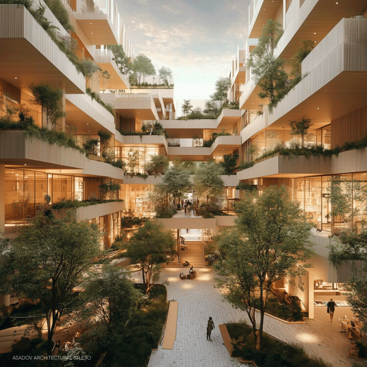
Urban masterplans remain an exploratory ground for unbuilt speculation, offering insight into how cities might recalibrate mobility, ecology, and collective life in response to accelerating environmental and social pressures. In this Unbuilt edition, submitted by the ArchDaily community, the selected projects bring together a range of large-scale proposals that examine urban centers, waterfront districts, infrastructural corridors, and cultural landscapes as spatial frameworks for reconnection and resilience. Rather than treating the masterplan as a rigid blueprint, these projects approach urbanism as an adaptive system shaped by climate, topography, infrastructure, and public space.
Across varied geographies, from Northern European town centers and Mediterranean coastal districts to Central Asian polycentric hubs and Gulf megacities, the proposals explore diverse architectural and urban strategies. They range from park-led civic transformations built over highway tunnels to elevated pedestrian networks above active transport systems, mixed-use blocks structured by historic planning logics, marina developments integrating environmental stewardship, and research-driven models for equitable landscape urbanization.
Image credit: Architecture of Coal in Modern Europe project, University College Dublin
We are excited to invite submissions for DARK MATTER: Revisiting the Architecture of Coal in Post-War Europe, an in-person conference hosted by the ACME (Architecture of Coal in Modern Europe) project (ERC Advanced Grant, 2024–2030), taking place at the Irish Architectural Archive, Dublin on 5+6 November 2026.
First Prize Winner: A Thread Through Time. Image Courtesy of Buildner
Buildner has announced the results of the Dubai Urban Elements Challenge, a landmark international design competition organized in strategic collaboration with Dubai's Roads and Transport Authority (RTA). With a total prize fund of 2,000,000 AED (approximately €500,000), the initiative represents one of the most significant publicly funded global design competitions focused on urban transformation.
The competition was conceived as a forward-looking procurement and innovation platform for one of the world's fastest-evolving metropolitan environments. Participants were invited to propose modular, climate-responsive urban elements—seating systems, shading devices, lighting infrastructure, wayfinding components, rest areas, and micro-retail structures—designed to enhance pedestrian life and strengthen Dubai's public realm identity.
On February 5, 2026, Almaty, Kazakhstan's largest metropolis, was officially declared the host city of the 2029 Asian Winter Games. The Host City Contract was signed between the Olympic Council of Asia (OCA) and the National Olympic Committee of the Republic of Kazakhstan during a ceremony in Milan, Italy, one of the host cities of the ongoing Winter Olympics. Established in 1986 in Sapporo, Japan, the Asian Winter Games will mark their tenth edition in 2029 and are held approximately every four years. The announcement follows an earlier decision to postpone the Games, which were originally scheduled to take place in the Trojena ski resort, masterplanned by LAVA and currently under construction as part of the NEOM mega-project in Saudi Arabia.
Cities around the world share a common goal: to become healthier and greener, supported by civic infrastructure that restores ecosystems and strengthens public life. The question is how to reach this. Global climate targets, local building codes, and municipal standards increasingly guide designers and planners toward better choices. Still, many cities struggle to translate these frameworks into everyday, street-level comfort and long-term ecological protection. What happens if the city is no longer treated as a traditional city, but as a national park?
National parks operate through systems of protection that treat land as a network of ecological relationships rather than a collection of isolated sites. They establish a shared baseline for what must be preserved, maintained, and made accessible over time. When this logic is applied to the urban environment, success can inspire pride and a sense of shared responsibility among designers, policymakers, and residents, fostering a collective commitment to health, habitat, and civic infrastructure.
January 26 marks the International Day for Clean Energy, an initiative aimed at raising awareness and mobilizing action for an inclusive transition from fossil fuels, such as coal, oil, and natural gas, to power generation systems with lower greenhouse gas emissions and fewer pollutants. The term "clean" signals a fundamental shift away from extractive, finite, and exhaustible energy sources toward systems based on renewable resources or on capturing energy embedded in natural processes. In a world grappling with climate change, clean energy plays an important role in reducing emissions and expanding access to reliable power. However, being labeled "clean" does not exempt these systems from the impacts associated with their production, deployment, and commercialization. In this context, architectural knowledge related to space, materiality, and habitation becomes relevant for supporting a transition toward energy systems that are sustainable over time. As stated by the United Nations, the science is clear: to limit climate change, reliance on fossil fuels must end, and buildings must be heated, lit, and electrified through clean, accessible, affordable, sustainable, and reliable power sources.
India's built environment has, in recent years, gained visibility through a growing number of transformative architectural and infrastructure projects. Cities and towns scale faster each year, despite looming concerns around climate and economic volatility. The nation has shown resilience in balancing rapid urbanization with resource constraints; this is no small feat. India's architectural practices rarely rely on novelty alone; they are built on systems that have existed for centuries. Through ArchDaily's Building for Billions, recurring stories have highlighted the social intelligence and adaptive capacity embedded in these practices, revealing an architecture that operates less as isolated form and more as infrastructure.
In 2025, India's most consequential design projects unfolded largely out of sight. While public attention gravitated toward museums, cultural landmarks, and visually arresting façades, the architecture that most decisively shaped daily life existed underground, at the city's edges, or inside secured compounds few citizens would ever enter. Sewage networks were rebuilt, flood tunnels bored beneath dense neighborhoods, substations lifted above floodplains, and data centers multiplied across peri-urban landscapes. These were not peripheral works of engineering; they were the spatial systems that allowed Indian cities to remain functional through record heatwaves, erratic monsoons, and accelerating urban growth.
As preparations advance for the Milano Cortina 2026Olympic Winter Games, set to take place from February 6 to 22, 2026, this edition introduces one of the most geographically wide-ranging configurations ever implemented for the Winter Olympics. Extending across two cities, two regions, and two autonomous provinces, the competitions will be staged over more than 22,000 square kilometres of Northern Italy. Metropolitan venues in Milan are paired with longstanding Alpine centres in Cortina d'Ampezzo, Livigno, Bormio, Anterselva, and Val di Fiemme, creating a framework that bridges urban and mountain contexts. More than 90 per cent of the venues are existing or temporary facilities, reflecting a strategy centred on adaptive reuse, selective upgrades, and long-term integration into regional sport and cultural infrastructures. Nearly 2,900 athletes will compete in 116 events, including the debut of ski mountaineering and several new mixed-gender formats that signal evolving approaches to winter sports programming.


: Techformance. Image © Jimmy Ho, Courtesy of UABB2025")
: Techformance. Image © Jimmy Ho, Courtesy of UABB2025")
: Techformance. Image © Jimmy Ho, Courtesy of UABB2025")


 / TAISEI DESIGN Planners Architects & Engineers. Image © Katsumasa Tanaka")