From October 21st, 2023, to March 3rd, 2024, the Vitra Design Museum is hosting a retrospective exhibition featuring the work of Iwan Baan. Known for his world-renowned architecture photography, “Iwan Baan: Moments in Architecture” provides a comprehensive overview of Baan’s extensive portfolio. At its core, it showcases the artist’s ability to capture the essence of contemporary architecture, along with the urban and social contexts associated with it and the people who inhabit these various spaces.
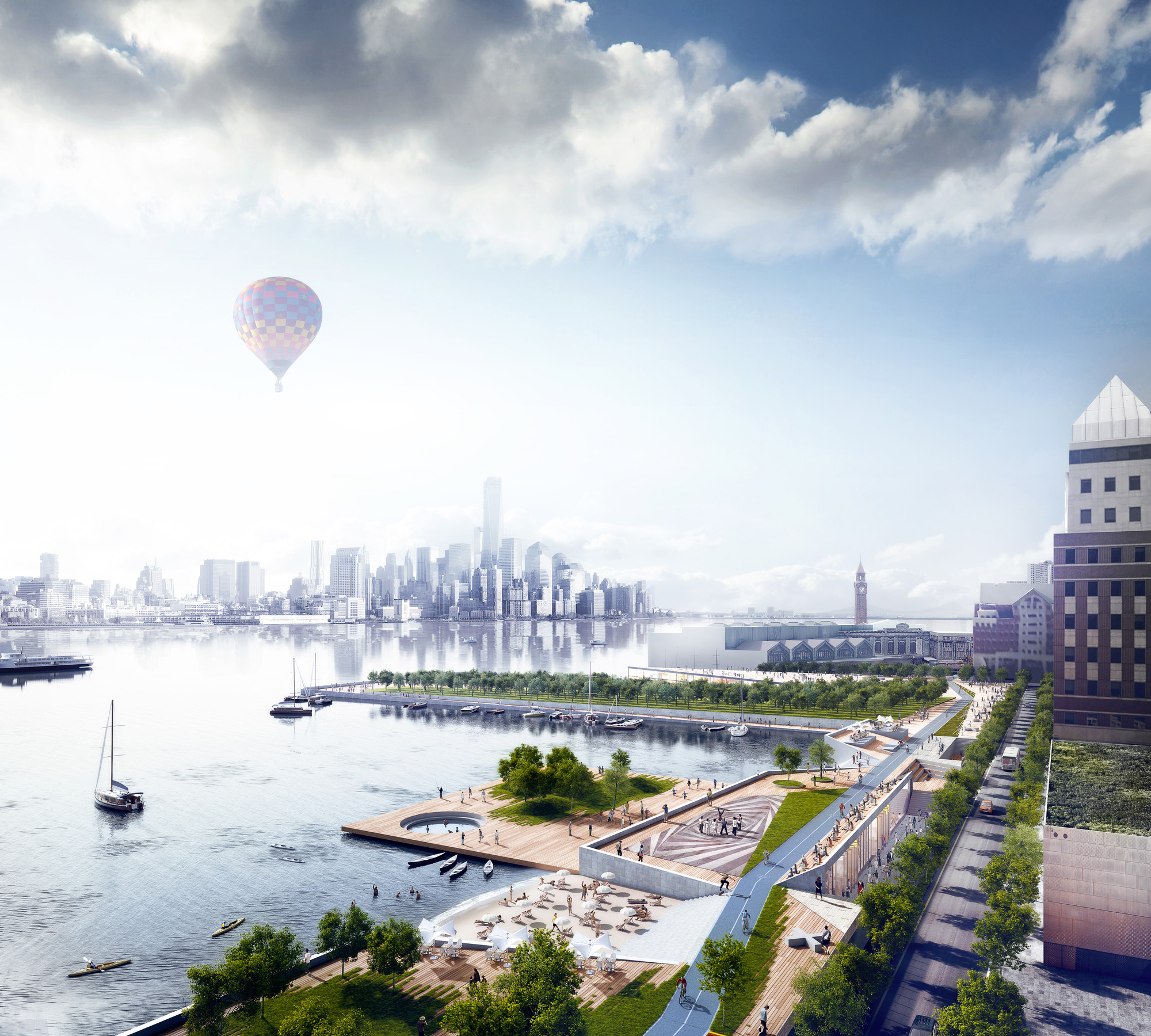
New York City is the pinnacle hybrid between the vibrant and granular neighborhoods that Jane Jacobs once envisioned and the sweeping urban innovations of Robert Moses. However, its diverse population has experienced hardship over the last twenty years, forcing the city into a recursive wave of self-reflection to reevaluate the urban strategies, design trends, and global transportation methods that it had grown so accustomed to. After the September 11th and Hurricane Sandy tragedies, the delicate balance between promoting a sense of individual culture and the strength in unity that New Yorkers are so often known for served as the lifeblood for revitalization. New York City has consistently handled adversity, by always rethinking, redesigning, and rebuilding this city for a better future.
KPF with NYCHA created a resiliency and renewal program for the Red Hook Houses in Brooklyn, severely damaged by Hurricane Sandy. The redevelopment plans aim to reduce the vulnerability of the area and its community.
Please join us for the opening of Structures of Coastal Resilience: Designing for Climate Change!
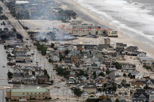
The devastation caused by Hurricane Sandy in October of 2012 has highlighted the vulnerability of urban coastal areas to the effects of catastrophic storms and climate change. Coastal communities must adapt planning strategies to mitigate the risk posed by these natural hazards.
Structures of Coastal Resilience (SCR) matches the latest science with urban and landscape design to propose actionable solutions for buffering against storms. Structures of Coastal Resilience (SCR) is a Rockefeller Foundation-supported project dedicated to studying and proposing resilient designs for urban coastal
"SU+RE HOUSE powers itself with clean solar power, and uses 90 percent less energy than its conventional cousins," says the winning team. "In the aftermath of a storm, SU+RE HOUSE can become a hub of emergency power for surrounding neighborhoods."
A vision to protect post-SandyManhattan against future superstorms, Bjarke Ingels Group’s (BIG) “Dry Line” seeks to form a continuous storm barrier around lower Manhattan by transforming underutilized waterfront spaces into a “protective ribbon” of public parks and amenities. Though ambitious, the project is not impossible; it was one of six winners in the US’ Rebuild by Design competition that is envisioning ways New York can protect its edge.
Mathews Nielsen Landscape Architects' designs for Pier 42. Image Courtesy of Mathews Nielsen Landscape Architects
As part of Mathews Nielsen Landscape Architects' ongoing blog at Metropolis Magazine about effective implementation of landscape design principles, this article discusses one of the more unusual methods developed to create resilience and prevent storm damage: oysters. Drawing on her experiences creating an oyster reef at Mathews Nielsen Landscape Architects' Pier 42 project in New York, Johanna Phelps explains the challenges and opportunities that arise in establishing this unusual type of natural infrastructure in an urban location.
Since Hurricane Sandy struck New York in 2012, the city’s waterfront design discussions have focused on ideas of resiliency and planning for storm events. The recent Rebuild by Design competition sponsored by the U.S. Department of Housing and Urban Development (HUD) and the Presidential Hurricane Sandy Rebuilding Task Force, featured six winning proposals that all envisioned a beefed-up Manhattan shoreline capable of handling large storm events and other hazards effects of climate change. Of the handful of ambitious designs, Scape/Landscape Architecture's Living Breakwaters plan was the most interesting: the project called for the reestablishment of New York's erstwhile oyster reefs, which the architects said would improve local ecology.
Exterior Of The Prefabricated Relief Housing Units. Image Courtesy of GOTHAMIST / JAKE DOBKIN
With hurricanes Sandy and Katrina etched into recent memory, the need for post-disaster relief housing is now. New York City and Garrison Architects have developed a modular, prefabricated housing system to relieve displaced citizens during the next "superstorm." At only 40' by 100' long, they can squeeze into the city's smallest corners -- all while having kitchen, bedroom, bathroom and storage spaces. The prototype is on display in Brooklyn - but you can see the entire design at the A/N Blog.
Yesterday, US Housing and Urban Development (HUD) Secretary Shaun Donovan announced OMA, BIG and four other teams as the winner of "Rebuild by Design", a competition aimed at rebuilding areas affected by Hurricane Sandy focusing on resilience, sustainability and and livability.
In total, HUD have allocated $920 million to the six projects in New York, New Jersey and Long Island to enable the completion of this vision.
Read more about the winning schemes after the break
An aerial rendering from the Sasaki/Rutgers/Arup team shows Barnegat Bay, New Jersey. A threatened barrier island is visible on the right, and in the middle is a redeveloped area where people could, in theory, move. Image Courtesy of The Atlantic Cities
If you lived in a region repeatedly devastated by storms, would common sense be enough to make you leave your memories behind? Two of the ten proposals for the Rebuild by Design competition (which included proposals from OMA and BIG) tackle this issue, providing designs that compel communities to move to safety. To learn more about this sensitive and increasingly relevant social and political issue, known as "Managed Retreat," check out James Russell's article on The Atlantic Cities.
Between Hurricane Sandy in the USA and ongoing storms and floods damaging large areas of Britain, the issues of flood prevention and coastal defense are now a top priority for planners on both sides of the Atlantic. This article in the Guardian asks whether it might be time to give in to the sea and rethink our affinity for coastal living; and this one on Architecture Boston asks to what extent society should be expected to foot the bill for those in high-risk areas, and wonders how, legally, the state could encourage people to live elsewhere.
OMA’s comprehensive strategy to rebuild the New Jersey city of Hoboken, after the devastation of Hurricane Sandy, has been selected as one of ten initiatives moving forward in the Department of Housing and Urban Development’s (HUD) Rebuild by Design competition. The proposal, Resist, Delay, Store, Discharge, focuses on establishing resiliency through the integration of key infrastructural elements that not only protects coastal neighborhoods, but also the entire city of Hoboken.
After three months of in-depth analysis and public outreach, the U.S. Department of Housing & Urban Development (HUD) has shortlisted 10 design “opportunities” for the third and final round of Rebuild by Design. The design competition, focused on making New York’s Sandy-effected regions more resilient, sustainable, and livable, will now have the final project teams collaborate with local and regional stakeholders in developing their projects over the next five months. The goal is to arrive at projects that are implementable and fundable, leveraging the variety of federal recovery investments being made in the region.
OMA, BIG and WXY are just a few practices involved in the final round. Read on to review a glimpse of each shortlisted proposal.
Architecture Research Office and dlandstudio have proposed Wetlands in Lower Manhattan to deal with the next Hurricane Sandy. Image Courtesy of Architecture Research Office and dlandstudio
In this article on Fast Company, seven leading architects in the field of designing for disaster - including Peter Gluck, Michael Manfredi, and principals of James Corner Field Operations and Snøhetta - give their take on what lessons Hurricane Sandy, one year on, has taught us. Their responses raise a number of issues, but above all share one common theme: urgency.
WXY Studio's East River Blueway Plan. Image Courtesy of WXY Studio
Since Hurricane Sandy struck New York, much has been made of "green infrastructure" and its potential to defend cities against waves and floods. Now though, two articles, from the New York Times and Grist, claim that green infrastructure would actually protects us very little. But, since engineered "gray" solutions, such as storm-walls, also have their limitations (namely just moving the surge elsewhere), it seems the solution is a combination of both "gray" and "green" (moving the surge to where it can safely release its energy). Read the original articles here and here.
The finalists of the 2013 ONE Prize, a competition exploring the social, economic, and ecological possibilities of urban transformation, have just been announced. The 2013 competition focused on severe climate dynamism, calling for innovative and thoughtful design proposals and urban interventions that intend to alleviate storm impact and answer the question: "How can cities adapt to the future challenges of extreme weather?"
https://www.archdaily.com/444978/2013-one-prize-finalists-announcedKatherine Allen
Operation Resilient Long Island (ORLI) has just announced the winners of its 3C: Comprehensive Coastal Communities ideas competition. Entrants were asked to design solutions that were not just resilient but also contextually sensitive and pragmatic to the devastating aftermath of Super-storm Sandy as well as all future natural disasters. Over 60 submissions were received from 20 different countries and 32 finalists were engaged in a public education strategy through a public voting campaign. A jury panel of eight leading professionals in the fields of architecture, urban planning and disaster mitigation met in mid-September to review the top finalists and selected 3 winners.
U.S. Housing and Urban Development (HUD) has announced ten shortlisted teams to compete in the multi-stage regional design competition “Rebuild by Design.” Each team will aim to “promote innovation by developing regionally-scalable but locally-contextual solutions that increase resilience in the region, and to implement selected proposals with both public and private funding.”