Waterway bathroom concept by Haihua Zhang and the bathroom collection AXOR Archivio by Barber Osgerby. Image Courtesy of AXOR
Water has always occupied a unique position in architecture: elemental yet elusive, functional yet symbolic. It is both a material and a medium that shapes cities, structures rituals, and influences how space is perceived. Across cultures, water is understood not only as a source of life but as a carrier of meaning, associated with purification, renewal, and continuity. Its presence in the built environment often extends beyond utility, becoming a device through which architecture engages the senses and constructs atmosphere.
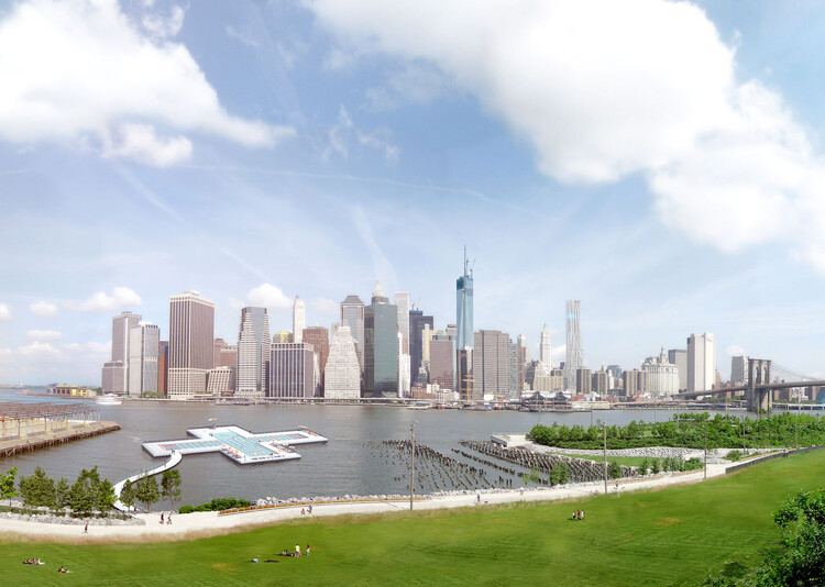
Friends of + POOL has announced the next steps in the realization of New York City's first water-filtering floating swimming pool, to be installed at Pier 35, north of the Manhattan and Brooklyn Bridges. The project seeks to provide safe public access to swimming in the city's rivers by integrating a custom-designed filtration system into a floating pool structure. Installation at Pier 35 is scheduled for May 2026, when the pool will enter its final phase of evaluation. Public access will be contingent on the successful completion of large-scale filtration testing and the full build-out of the facility for safe public use.
Contrary to common belief, artificial islands have a lengthy historical background in many regions worldwide. This heritage dates back to the reclaimed islands in Ancient Egypt, the hundreds of Stilt crannogs found in Scottish and Irish lakes and waterways, and the ceremonial islands constructed during the Aztec Empire. By definition, an artificial island is an island that has been constructed by humans rather than formed through natural processes. Artificial islands can be built for many different reasons, and these reasons are only increasing as the world faces the looming issue of space scarcity.
In the past, these islands were intended for ceremonial or agricultural purposes, often verging on solutions for urban space. More recently, the islands have been built to mitigate overcrowding, reclaim land, provide new urban expansions, and meet infrastructure and industrial needs. Artificial islands also have certain strategic advantages and economic gains and can lead to geopolitical benefits. However, these types of projects come at a significant cost to our ecosystem, harming the environment in severe and vast ways.
Eastern and Southern Europe is enduring a severe heatwave, with temperatures reaching over 40 degrees Celsius in many countries including Greece, Croatia, Macedonia, and Romania. Driven by hot air from North Africa, this prolonged heatwave has raised significant threats for residents and has strained the cities’ mechanisms for protection and climate mitigation. As the heatwaves expose the vulnerabilities of urban infrastructures, cities across Europe are striving to implement measures to address these challenges.
Foster + Partners has just unveiled the designs for the Xicen Science & Technology Center at the heart of the Yangtze River Delta Region in Shanghai,China. The project is strategically located along the Shanghai – Huzhou development axis, ensuring connectivity to the city center through high-speed rail links. Drawing inspiration from the timeless allure of the surrounding water towns, the center blends new and existing waterways to create a community featuring residential, commercial, and recreational spaces.
Throughout history, rivers played a crucial role in the social structures of cities. Along riverbanks, communities often congregated for socializing, swimming, and fishing. Swimming in rivers was a popular summertime activity enjoyed by people of all ages. Whether it was the Thames in London or the Seine in Paris, rivers were bustling with swimmers; integrated into urban lifestyles.
New York Governor Hochul has announced a partnership with the nonprofit Friends of + POOL to open the first urban river-sourced swimming facility in the United States. Utilizing + POOL’s design and technology, the 2,000-square-foot plus-shaped swimming pool is set to open in New York City’s East River in the summer of 2024. In 2010, four young designers, Archie Lee Coates IV, Dong-Ping Wong, Jeffrey Franklin, and Oana Stanescu, established + POOL with the goal of providing New Yorkers with access to free and safe river swimming. Now the state promised to invest $16 million to pilot and scale the system, hoping to expand it across the state of New York.
International office MVRDV has been selected by the Taiwan Ministry of Economic Affairs to design the Hoowave Water Factory, a large-scale redevelopment of Huwei’s Beigang and Anqingzhen waterways. The project combines a strategic master plan with the landscape design in an effort to move beyond the mono-functional approach for controlling and distributing water. Besides storing and capturing water, the proposal also opens up access to the river and the natural ecosystem by integrating cycling paths, cultural amenities, and ecological systems. The master plan also includes a comprehensive strategy for flood resilience while improving the quantity and quality of available water. The project is expected to be completed in 2026.
GIS analyst and Hungarian cartographer Robert Szucs has shared an impressive collection of maps that bring together all the drainage basins of the world in vibrant colors. Titled GrasshopperGeography, the maps showcase the rivers and watercourses of the world, featuring the basins of selected regions, countries and continents.


. Image Courtesy of Friends of + POOL")
. Image Courtesy of Friends of + POOL")
. Image Courtesy of Friends of + POOL")