Every year, World Population Day is observed on July 11th, aiming to increase people's awareness of various population issues, such as the importance of urbanization, genderequality, poverty, health, and human rights. In 2025, under the theme "Empowering Youth to Build the Families They Want," the United Nations draws attention to the largest generation of young people in history, many of whom are coming of age in rapidly urbanizing contexts. Urban centers remain key to understanding these demographic patterns, as cities continue to attract populations seeking opportunity, stability, and access to essential services. Today, more than half of the global population resides in urban areas, a share projected to increase to 66% by 2050.
More than half of the world's population resides in urban areas, with over 4 billion people depending on cities as their main environment. According to the United Nations’ latest report on populations in cities, this number is expected to continue to increase over the next 50 years, prompting cities worldwide to strive to find better ways to accommodate their growing population while transitioning to more sustainable urban practices. To highlight this responsibility, the United Nations has declared July 11th the World Population Day.
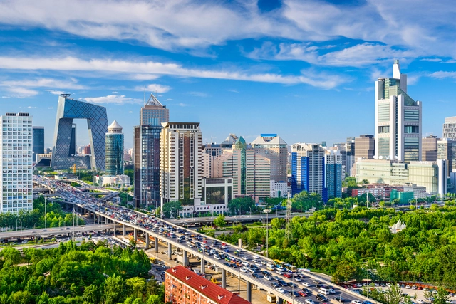
Under this year’s theme, “To Leave No One Behind, Count Everyone,” the UN aims to also draw attention to the importance of data collection for reflecting societal diversity. The growth of world cities is part of this equation as an important measure for understanding global population trends. The following list presents the top 20 cities worldwide in 2024, ranked by the population size of their metropolitan areas. Comparing the results to the previous editions, the only cities to reduce their size are the two cities from Japan, Tokyo and Osaka. The highest growth rates can be observed in African mega-cities, Kinshasa and Lagos, while China continues to be the most present country in the list, with 5 metropolises present in the top 20: Shanghai, Beijing, Chongqing, Tianjin, and Guangzhou.
In recent years, India has emerged as a focal point for architects and urban designers from around the world. From the rich legacy of masters and emerging firms to smart city initiates being established across the peninsula, the acts of decolonization in architecture design to the evolution of a modernized vernacular, India has been demonstrating the power of supporting good architecture and urban design. This year, ArchDaily launched ArchDaily Building for Billions, a column that discusses the effects of population rise, urbanization, and economic growth on India’s built environment. Building for Billions was fueled by the recognition of changes and innovative projects washing over the country.
According to the World Population Clock, the human population reached 8 billion on November 15th. According to the UN, this milestone represents a celebration of human longevity due to improvements in public health and medicine, but it also comes with warnings about inequality, limited access to food and resources, and environmental damage. Despite the impressive number, the annual World Population Prospect report shows that the global population is growing at the slowest rate since 1950, and it predicts a continued deceleration in the second half of this century.
As more than half of the worldpopulation lives in cities, an estimated 55.7%, according to UN-Habitat’s latest reports, the urban challenges are growing exponentially. The UN expects this number to increase to 68% by 2050, with close to 90% of this increase taking place in Asia and Africa. Accelerated urbanization can pose significant risks, such as increasing inequality, poverty, sectorized development, social exclusion, and pollution. In this context, a well-balanced urban agenda becomes crucially important in achieving inclusive, safe, and sustainable cities.
Half of the world’s population now lives in cities, according to UN-Habitat’s latest reports. While this number is set to increase to two-thirds by 2050, urban challenges are growing exponentially, making it more crucial than ever, to transform our cities. Annually, the world population review assesses the growth of cities and the number of residents living in metropolitan areas, to understand global evolution trends. In 2022, the list of the top 20 most populated countries remained similar to the 2021 edition, with a slight change in numbers and positions. Tokyo kept its status as the world’s largest city, with 37 million inhabitants, while Delhi and Shanghai, followed in second and third positions.
Comparing the results to the 2021 edition, the only decrease that can be seen in the top 20, involves both Japanese cities, Tokyo and Osaka. The rest of the list had, on average, a growth of 1.8% in the total of people residing in metropolitan areas. In fact, African cities Kinshasa in the Democratic Republic of Congo and Lagos in Nigeria gathered the highest rates, with respectively a 4.39% and a 3.54% increase in residents in 1 year. The largest city in the American continent is still Sao Paulo in Brazil, followed closely by Mexico City and Buenos Aires in Argentina, further down the table. In Europe, Istanbul is the most populous, with more than 14.5 million residents.
Hungarian analyst and cartographer Robert Szucs shared with ArchDaily another of his series of maps, this time addressing the population distribution on Earth. A large blackboard, identifying only the geopolitical boundaries of countries and continents, reveals bright constellations, representing human agglomerations and the world's great voids.
Engineer Matt Daniels has created a new interactive map to visualize the world's populations. Called 'Human Terrain', the project includes extruded block-by-block population data for cities across the world to give viewers fine-grain insight into population distribution. Daniels used data from the Global Human Settlement Layer and processed it using Google Earth Engine to create a mountainous digital landscape.
What would the world’s landscape look like if it were concentrated into one megalopolis? This graphic analysis illustrates the amount of land required to accommodate all 6.9 billion people based on the densities of cities across the globe. The differences illuminate the adverse affects of suburban sprawl.


 . Image © Gianluca Stefani")


