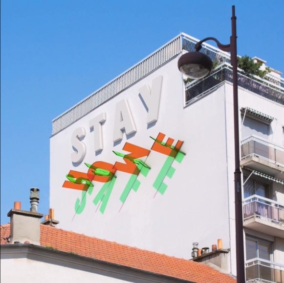
In many cultures, fire is a sacred element used in rituals of rebirth and renewal. It carries a dual symbolism, being both a creator and a destroyer—capable of illuminating paths or consuming everything in its wake. In Greek mythology, for example, Prometheus stole fire from the gods and gave it to humanity, marking it as a symbol of progress, knowledge, and creative power. However, fire also evokes destruction, as seen in biblical tales like that of Sodom and Gomorrah, where it was used as divine punishment. This duality was also evident in the 2019 fire at Notre-Dame Cathedral, which devastated its historic structure. The disaster sparked a wave of solidarity and led to unprecedented technological advancements, with restoration efforts utilizing digital tools such as laser scanning and Building Information Modeling (BIM) to recreate intricate details and preserve architectural heritage.
From the Colosseum's vast arches to the Pantheon's perfect dome, Roman architecture fused engineering precision with expressive form. These buildings reshaped the urban life of antiquity but also left traces that continue to guide contemporary design. Yet much of the knowledge behind their construction has been lost or obscured over time, like the geometry, the proportions, and methods. Today, new technologies are helping to recover that hidden layer of architectural intelligence, offering fresh perspectives on how Romans built with such ingenuity.
The heritage of Mexico City is extremely rich and diverse due to a long history that overlays like layers above the urban fabric since pre-Hispanic times. Currently, it is one of the largest cities in the world, and its heritage is reflected in its architecture, museums, historical sites, cultural traditions, protected sites, gastronomy, and much more. This chronology has been evidenced through various historical records. However, contemporary recording is essential in moments where we are writing history immediately with different digital tools.
When transparent facade elements deliberately evolve from the course of the sun, we can explore a fascinating slow movement in stark contrast to the hectic urban street life on the ground. Especially the French designer Pierre Brault has responded to the accelerated rhythm of our society with facade installations that combine the principle of the sundial with colorful pop design. His three-dimensional works made of recycled colored plexiglass mesmerize through simple but dramatic movements of colored shadows. In the interview, Brault explains his inspiration, the experimental approach and his interest in working responsibly with material.
If you haven't gotten a chance to visit Brasília, Joana França's photographic projects offer a comprehensive interpretation of the capital of South America's most populous country. França has dedicated a significant part of her career as an architecture photographer to the pursuit of amassing an impressive archive of images of the city planned by Lúcio Costa and Oscar Niemeyer.
We recently published an exceptional selection França's aerial photographs of Brasília divided by scale - residential, monumental, gregarious and bucolic. These overhead views solidify what, in theory, is already evident: the city lacks human scale, or the human scale of Brasília is just vast and (perhaps) not very human at all.
At different periods in history, the human scale and the approach of the building to the sensitive dimension correlated to the body were values pursued by the architects and an object of reflection for the theoretical production of the area. Although it is a virtue that a space can be perceived in a direct relation between the person and the building, there are cases, and more than that, some project scales, that can only be realized from the furthest perspective.
Capturing aerial photographs allows raising awareness of a project feature usually complex to capture using traditional methods. Based on the technological opportunities offered by small unmanned aerial vehicles (UAVs), commonly called drones, architecture photographers have begun to explore new ways of capturing a project in order to expose design decisions such as implantation, dialogue with the environment, or the relationship with nearby buildings.
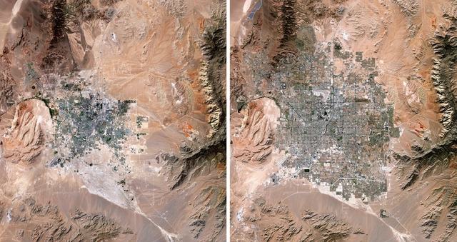
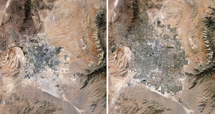
Las Vegas Expansion, 1989/2019. Source Imagery courtesy of The European Space Agency (ESA) Paris, France
Human impacts on Earth are a common issue nowadays, and many people say that there is no turning back. Climate crisis, greenhouse gases, exploitation of natural resources, production of solid waste and atmospheric pollution are some of the most pressing issues that the global community must address if we want to ensure a sound future for the next generations.
These topics can be viewed in full-color and high-definition in the new book Overview Timelapse: How We Change the Earth, by Benjamin Grant and Timothy Dougherty, which compiles 250 satellite and drone photographs of places on Earth that are in constant transformation.
Seeing from above – the aerial vantage point – is the illusion of knowledge. This was the idea of Frenchman Michel de Certeau, a historian who was interested in the everyday practices that occur on the ground, on the streetscape. In contrast to Certeau's view, satellite images can be a powerful tool to understand, predict, and strive for a better future for humankind. This is the mission of Benjamin Grant, founder of Overview, a platform that explores human activity on Earth through aerial imagery.
Interested in fostering "an experience of awe" through elevated vantage points of our world, Overview offers snapshots featuring traces of human activity on the surface of the planet. Photos of cities and other cultural artifacts join pictures of mesmerizing topography and natural beauty in an impressive archive of drone and satellite images. Awe abounds as we face not only some of the most impressive human endeavors seen from the sky, but also as we are confronted with the rather gruesome side-effects of our very existence on Earth.
Across the world, urban clusters have —to a greater or lesser extent— social and economic differences. Reflected in space, these imbalances of income and access to education, health, sanitation, and infrastructure generate ruptures more or less visible —although drastically felt.
Although a daily reality for some, socio-spatial inequalities can often go unnoticed. Photographer Johnny Miller states, "Discrepancies in how people live are sometimes hard to see from the ground... Oftentimes, communities of extreme wealth and privilege will exist just meters from squalid conditions and shack dwellings." Miller's photo series 'Unequal Scenes' seeks "to portray the most 'Unequal Scenes' in [the world] as objectively as possible."
Beijing Daxing International Airport / Zaha Hadid Architects. Image by @seven7panda
In architecture and urbanism, both proximity and distance from a certain object of study, whether on a building scale or urban scale, are frequent strategies that help us better visualize details and also have a broader overall perception, both essential for understanding the object in question. Changing the point of view allows different perceptions of the same place. By moving from the ground level, or from the eye-level, which we are accustomed to in everyday life, to the aerial point of view, we can establish connections similar to those achieved through site plans, location plans, and urban plans.
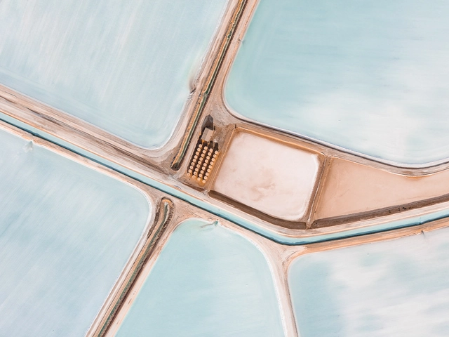
Munich-based photographer Tom Hegen has published a set of aerial images capturing the beauty of sea salt production seen from above. Theimages, shot from a small airplane in Western Australia, demonstrate the impact of human intervention on natural environments, and depict how even seemingly rural landscapes are alive with the hyper-globalized demands of humankind.
This video tutorial will teach you how to create detailed, 3-D environments from images taken by drones, using Photogrammetry to better contextualize our architectural projects.
The video covers the entire process, from flying the drone to using the RealityCapture software, including identifying plants and trees through an application for mobile phones and lastly viewing the architecture in 3D using Lumion.
https://www.archdaily.com/916230/how-to-create-3d-environments-from-images-taken-with-droneArchDaily Team
Videos
Droneports. Image Courtesy of Jonathan Ledgard and Norman Foster
A new video by AERIAL FUTURES explores the potential of droneports in East Africa and the Global South. The Norman Foster Foundation was one of the first groups to propose the creation of a droneport network to deliver medical supplies and other necessities to areas of Africa that are difficult to access due to a lack of roads or other infrastructure. The project aspires to have droneports across small towns in Africa and in other emerging economies by 2030.
Exploring the streets of foreign cities is profoundly engaging. Whether it's meeting new cultures, observing new architectures, or trying new food, travelers usually go for the typical sightseeing activities. However, some have quite a unique take on tourism and choose to think outside the box - or in this case, above it.
Hungarian photographer Márton Mogyorósy chose to explore the Catalonian capital from above, capturing aerial shots of the city. Drone photography has helped us see cities from a unique perspective, and with Barcelona’s dynamic urban fabric, the coastal city’s buildings and beaches have turned into vibrant geometric artwork.
We have seen rooftop helipads, restaurants, pools, and even gardens, but soon rooftops will be catering to a new service: drone delivery. Maida Vale’s Lyons Place, a residential complex designed by architect Sir Terry Farrell, will be the first in the UK to implement rooftop ‘vertiports’, encouraging drone delivery services.
Drone photography has been one of the biggest advancements in aerial photography and cinematography. Drones began making a huge impact on filmmaking in the early 2000s, but vast advancements in aerial and camera technology have dramatically increased the use of and demand for aerial footage in nearly every industry focused on digital content.
"Sand Castles (part II)" by Markel Redondo. Image Courtesy of Markel Redondo
The winners of the DJI Drone Photography Award have been announced, a competition calling for ideas to make creative use of drone photography, and to explore subject matters impossible to experience on foot. This year, the two winning projects consisted of a new perspective on Spain’s 3.4 million abandoned houses, and the documentation of salt production across Europe.
https://www.archdaily.com/892004/beauty-or-tragedy-aerial-imagery-of-spains-abandoned-housing-estates-wins-dji-drone-photography-awardNiall Patrick Walsh


\" by Markel Redondo. Image Courtesy of Markel Redondo")
\" by Markel Redondo. Image Courtesy of Markel Redondo")
\" by Markel Redondo. Image Courtesy of Markel Redondo")
\" by Markel Redondo. Image Courtesy of Markel Redondo")
