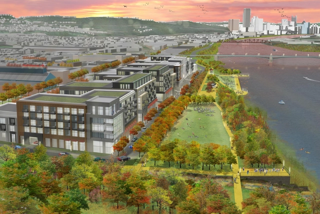
43rd St District View Back Towards Pittsburgh Courtesy of Sasaki Associates
With the advent of the High Line and the recent announcement about Chicago's Bloomingdale Trail, it's becoming clear that the 'parkway' is a powerful new force in urban planning, which has the potential to change the way cities around the world function. A new project in Pittsburgh seeks to harness these possibilities, as the city's history of industry has left its stamp upon the city in the form of a rusting industrial riverfront. A plan by Saski Associates envisages re-using this space to create a green belt, tying the city closer together. By adding pedestrian, cycling and light-rail transport routes, and creating plenty of green spaces, they hope to tap Pittsburgh's unrealized potential to be a river-front city, while encouraging geographical and social closeness amongst its communities.
More images and the architect’s description after the break…
In 2011, UN-HABITAT and Project for Public Spaces (PPS) signed a 5-year cooperative agreement to aspire to raise international awareness of the importance of public space in cities, to foster a lively exchange of ideas among partners and to educate a new generation of planners, designers, community activists and other civic leaders about the benefits of what they call the "Placemaking methodology." Their partnership is helping to advance the development of cities where people of all income groups, social classes and ages can live safely, happily and in economic security and in order to reach these ambitious goals, the duo recently released 10 informative steps that cities and communities can take to improve the quality of their public spaces.
It has been twenty years since the demolition of the Kowloon Walled City. To mark this, the South China Morning Post has created an info-graphic that details the facts and figures of what life was like inside this architectural oddity.
Read more about the madness that was KWC after the break...
In order to accommodate the expansion of the local tram system, La Fabrique Métropolitaine de la Communauté Urbaine de Bordeaux has commissioned OMA to design a new major urban development in the southern district of Bordeaux, France. Over the next five years, the masterplan will regenerate the neighborhoods of Bègles and Villenave d'Ornon by forging new connections to Bordeaux's central station and unlocking the potential for both city development and public space.
This project is part of the new identity for the "Porte Sud de Bordeaux" (Bordeaux south gate) and continues OMA's intensive recent engagement in Bordeaux, as the office has been working since 2010 on the masterplan for 50,000 new housing units in the city.
More on OMA’s Bordeaux masterplan after the break...
Via the Atlantic Cities "The would-be BMX track in Douglas Park, from Chicago's Bid Book."
In "How (Not) to Host the Olympics," I suggest that, when it comes to Olympic Planning, there is one Golden Rule: “The best thing to do if you’re bidding for the Olympics, Is to Not Get the Olympics.”
Badger follows up in Chicago, a city that bid - hard - for the 2016 Olympics (which will take place in Rio de Janeiro). As she puts it: "We often ask what Olympic cities really get in return for all the money, energy, and construction chaos invested in hosting the world's largest sporting event. But the story of cities that vie for but never win the Games raises a different question.
'What does putting together a bid that is unsuccessful leave you?'"
The proposal, ‘Athens PubliCity: an urban neuron for a new city center’, for the Re-Think Athens competition organizes a public space processing system which develops and expands like an “urban neuron”. Designed by Nikiforidis-Cuomo Architects, their concept becomes an entire living framework aiming to re-activate and revitalize the urban body. The system acts as a familiar, habitable and dynamic framework able to “contain” events and situations of both collective and individual actions. More images and architects’ description after the break.
Danish architecture firm, BIG - led by Bjarke Ingels - has been announced as the winner of an international invited competition for the design of Europa City, a 800,000 square meter cultural, recreational and retail development in Triangle de Gonesse, France. Combining city development with an open landscape, Europa City creates a dynamic center of activity for visitors and residents, appealing to the variety of functions of city life. Europa City is situated along the route from Charles de Gaule Airport to Paris and has a wide range of programs that is part of a larger initiative to attract international tourism into the northern parts of Paris.
The revamped Transbay Transit Center in downtown San Francisco broke ground earlier this week, a project that will introduce a 1.5 million square foot development that will be part transportation hub, part public park and urban space, and part offices and retail establishments. The massive undertaking, designed by renowned architecture firm Pelli Clarke Pelli will bring together 11 systems of local and national transportation, serving 45 million people per year. In addition to securing access to myriad transit lines, the project will also provide downtown San Francisco with a 5.4-acre rooftop park, designed by PWP Landscape Architecture, along with numerous cultural programs. The project is budgeted at 4.2 billion dollars and is projected for completion in 2017. It is funded in part by the construction of a 1,070-foot tower that is adjacent to the Transbay Transity Center. It is also designed by Pelli Clarke Pelli and is slated to be the tallest tower in San Francisco. The tower will secure 60 stories of office space and jobs and will contribute to the projected $87 billion of revenue through 2030.
Join us after the break for more details on this project.
Designed by da architecture, their first prize winning proposal in the IBA Basel 2020 competition, Das Band meiner Stadt (The band of my city), is a new dynamic that is brought to the Eastern railway station district of Quartier du Lys, which becomes the new landmark of the city of Saint-Louis. The development of this new district on the western side of the station area is characterized by a well-mixed, multi-use business district with offices, commercial and residential programs. This will benefit Saint-Louis train station and help the stream of travellers to further increase. More images and architects‘ description after the break.
In an effort to “unlock people’s imaginations” about Penn Station and Madison Square Garden, the Municipal Art Society (MAS) of New York has challenged Santiago Calatrava, Diller Scofidio + Renfro, SHoP Architects and SOM to propose four new visions that exemplify the potential of the highly disregarded area.
The challenge comes amidst a heated debate on whether or not the city should restrict Madison Square’s recently expired special permit to 10 years, rather than in perpetuity as the arena’s owners - the Dolan family - has requested. This would allow time for the city to “get it right” and come up with a viable solution for the arena and station that would not only “improve the safety and quality of life for millions of people but also benefit the economy”. Think Kings Cross in London. With a thoughtful mix of public and private investments, the crime-ridden transfor station was transformed into a thriving cultural destination.
Courtesy of Michael Van Valkenburgh Associates, Inc.
Chicago is set to be the next U.S. city to park-ify on one of its abandoned rail-lines. First proposed back in 1997, the 2.7 mile, 13-acre Bloomingdale Trail and Park is proposed for a stretch of abandoned railway trestle dating from 1910, which has been lying unused since the turn of the century. And, even though it is already being compared to New-York'sHigh Line, the planners are adamant that the park will be an entirely different animal to its New York cousin.
Read more about Chicago's unique proposal after the break...
Chosen as one of the five finalists in MOMA’s Young Architectural Program (YAP), Yalin Architectural Design’s proposal ‘IM-Debris’ focuses on how Istanbul and all the other cities in the world have to come up with local solutions to their own problems in global standards. The main purpose of this design is to be within the rubble which we are usually used to observe from a distance, to form a place with every possible material that is left from a construction and to have the visitors re-discover where it came from, in a place designed by it in the first place. More images and architects’ description after the break.
As a city, Hong Kong doesn't have it easy; impossibly dense and smothered by unsympathetic hilly terrain, the gymnastics that it performs to survive has lead to the growth of unique urban spaces. Cities Without Ground deconstructs the unfathomable spaghetti of pedestrian bridges, tunnels and walkways, which make up pedestrian Hong Kong. The book, created by motley trio of architects and academics: Jonathan Solomon, Ciara Wong and Adam Frampton, graphically dissects this labyrinth in a series of snappy axonometric drawings of 32 various routes through the city.
Read more about the story of Hong Kong's pedestrian maze after the break...
"The architect has to continue doing what he or she has done for the last 5,000 years, which is to make objects of great beauty, which uplift the spirits of whoever commissions them or occupies them or sees them. But, increasingly, [the architect] has to take on two other things, which is: to make things in such a way that they are part of an environmental whole; but also to be much more conscious of what the social impacts are of the decisions the architect may make. [...] The architect, unless they want to wipe themselves out and become aesthetes, has to deal with these big issues." - Ricky Burdett
As the world becomes increasingly urbanized, there lies an important question ahead of us. There can be no doubt that cities will grow, but how can we make sure that they grow sustainably and - what's more - equitably?
To get to the bottom of these important questions, we spoke with Ricky Burdett, a professor of Urban Studies at the London School of Economics (where he directs the program LSE Cities), the author of The Endless City, and one of the world's leading experts in urban planning. Not only was he the Chief Advisor of Architecture and Urbanism at the London 2012 Olympics, but he is also a founder of the Urban Age Project, an interdisciplinary investigation into the future of cities. We caught up with Burdett while he was in Chile, invited by CREO Antofagasta to advise on the development of Chile's sprawled-out city of Antofagasta.
Burdett had so much to share about his varied experiences that we've decided to split this AD Interview into two. Part I (above) covers Burdett's conception of what architecture is/should be; the London Olympics; and his strong opinion on the state of architecture in England today.
The second part of this interview, which you can see after the break, explores Burdett's work studying urban environments - including the Urban Age project; the secrets to sustainable, equitable growth (for more on Burdett's take on this, read Jared Green's article "The Rise of the Endless City"); and how architects and policy makers must work together if we are to design cities that serve the greater social and environmental good.
With everything today changing and the fishing architecture gone, the village of Sancti Petri owes its importance to the past tuna industry and seafarers. This first prize winning proposal in the competition for the urban and architectural design of the Península of Sancti-Petri aims to give back the original meaning to the peninsula by reinterpreting architectural and spatial values of the past. Designed by BAKPAK Architects, this "new town" is divided into 13 themed compact-use sets, and each of them are made up of modules. More images and architects' description after the break.