Think about the city or town where you live. How long does it take you to get to the grocery store on foot? Is your school or work close enough to walk to? What about a public park, a doctor’s office, a daycare, or any other places that you visit on a daily basis? While some cities have already considered what it means to live near all of these necessities, others are revamping their urban planning strategies and designing their neighborhoods to be more pedestrian-friendly with the concept of a “15-Minute City”.
The Un-Habitat or the United Nations agency for human settlements and sustainable urban development, whose primary focus is to deal with the challenges of rapid urbanization, has been developing innovative approaches in the urban design field, centered on the active participation of the community. ArchDaily has teamed up with UN-Habitat to bring you weekly news, article, and interviews that highlight this work, with content straight from the source, developed by our editors.
Around 440 fast-growing cities in emerging economies will contribute by 2025, to nearly half of global economic growth. If given the right planning and management tools, this urbanization “can be transformative, creating jobs, reducing poverty, and improving citizens’ quality of life”. As a matter of fact, the Global Future Cities Programme (GFCP) aims to deliver this required support. Based on urban planning, transport, and resilience principles, the program provides “technical assistance for a set of targeted interventions to encourage sustainable development and increase prosperity while alleviating high levels of urban poverty”.
Satellite image of Bahir Dar (Ethiopia) Support of the Sustainable Structure Plan of Bahir Dar. Image Courtesy of UN-Habitat
The Un-Habitat or the United Nations agency for human settlements and sustainable urban development, whose primary focus is to deal with the challenges of rapid urbanization, has been developing innovative approaches in the urban design field, centered on the active participation of the community. ArchDaily has teamed up with UN-Habitat to bring you weekly news, article, and interviews that highlight this work, with content straight from the source, developed by our editors.
In order to support local governments in developing countries to implement the New Urban Agenda and the Sustainable Development Goals, UN-Habitat has created the Participatory Incremental Urban Planning Toolbox, “a step-by-step methodology to assess, design, operationalize and implement urban planning processes”. The guideline proposes a timeline of phases, blocks, and activities, helping city leaders, stakeholders, and the community to have a comprehensive and strategic overview of the whole strategy.
Henning Larsen’s proposal for Seoul Valley was selected as the winner of the Central Seoul Development Competition. Seeking to become a new home for the public in the center of the city, the mixed-use development “merges Seoul’s global commercial profile with an ecological return to downtown pedestrian life”. Other entries included schemes by MVRDV and SOM.
In the introduction of Cities for People, Jan Gehl stated clearly that most cities have neglected the human aspect when planning the built space. While technologies have allowed us to build large, our focus shifted from creating architecture for humans to erecting structures that look like they are meant for a different kind of species. Top-down urban planning decisions have ignored scales adapted to the senses and organic growth, and new ideologies prioritized speed, functionality, and profitability.
Dictating our city experience, scale, this major spatial component related to the human dimension, stimulates our senses, and influences our well-being. In this article, we lay down historical changes and underline scientific facts to highlight how scale can impact our daily city life, guided by Eden of the Orient, a series of photos by Belgian photographer Kris Provoost, portraying a battle of scale in Hong Kong.
The built manifestation of an ideology, the urban landscape left behind by the socialist regimes around Europe are removed from the aspirations of contemporary urban living, thus trigger a unique process of re-appropriation of the post-soviet landscapes. The short film Landscape Architecture: Rethinking The Future out of a Totalitarian Past created by Minimal Movie invites a conversation around urban planning, cultural identity, and community building relating to the urbanism and architecture of Ukraine's Socialist Era.
The Un-Habitat or the United Nations agency for human settlements and sustainable urban development, whose primary focus is to deal with the challenges of rapid urbanization, has been developing innovative approaches in the urban design field, centered on the active participation of the community. ArchDaily has teamed up with UN-Habitat to bring you weekly news, article, and interviews that highlight this work, with content straight from the source, developed by our editors.
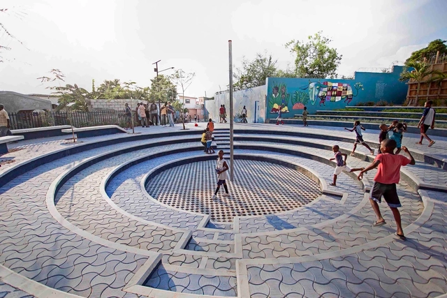
Associated with crime, waste, and garbage, Dandora in Nairobi’s Eastlands is home to 140,000 or so residents. In an on-going collaboration, between local residents and youth groups, UN-Habitat, Making Cities Together Coalition, and the Dandora Transformation League, the Model Street project has been transforming the garbage-filled community spaces into waste-free, attractive, and engaging places. Focusing on improving the shared courtyard spaces of residential compounds, an annual competition led by the youth of the neighborhood, the Changing Faces Challenge, became an initiative mobilizing citizens across Nairobi.
More than 55% of the world’s population lives in cities, with that number only expected to increase in the coming decades. Despite the rising population in urban areas, local governments continue to raise flags about inadequate infrastructure and the declining quality of life that cities are facing. Perhaps the large scale problems that we typically categorize as urban innovation, inclusion, and infrastructure, can be solved if we get to the root of the smaller troubles, that we may not even know existed. It’s time to take urban issues off the back burner and improve cities not just for today, but for the long term future.
Elche, Spain. Created by @dailyoverview, source imagery: @maxartechnologies
There is evidence that the orthogonal grid plan, which is one of the most common types of urban planning today, dates back to antiquity. Streets intersect at right angles to each other, resulting in a grid composed of streets, avenues, blocks, squares, parks, among other urban spaces.
In the mid-1990s, when I was an editor at Progressive Architecture, jurors for the magazine’s awards program gave an Urban Design Award to Peterson Littenberg Architects for a plan the small New York firm had devised for then-stagnant Lower Manhattan.
At the time, the southern tip of Manhattan ranked as the third-largest downtown business district in the United States. The tightly packed 1 square mile contained a bevy of venerable buildings, among them the New York Stock Exchange, the former headquarters of J.P. Morgan, and the fortress-like, neo-Renaissance Federal Reserve Bank of New York. Though the vast majority of Americans regarded the district as a powerful financial hub, people close to the scene saw it as a place with grim prospects. More than a quarter of its commercial space stood vacant. Companies were leaving Lower Manhattan for Midtown and more distant locales. Many of the office buildings were regarded as obsolete.
The Un-Habitat or the United Nations agency for human settlements and sustainable urban development, whose primary focus is to deal with the challenges of rapid urbanization, has been developing innovative approaches in the urban design field, centered on the active participation of the community. ArchDaily has teamed up with UN-Habitat to bring you weekly news, article, and interviews that highlight this work, with content straight from the source, developed by our editors.
“People all over the world are increasingly demanding a say in the way that their cities are planned and designed”.For our third collaboration, discover UN-HABITAT’s guideline on achieving quality public spaces, a site-specific assessment consisting of a series of activities and tools that help understand the quality of the selected area and plan future design and planning solutions on the site through participatory approaches. Focusing on open public space, within a five minutes walking distance, the guide helps users gather and analyze information, creating a logical transition from needs to design.
Laurel Canyon, Los Angeles, was a nexus of counterculture activity in the 60s. Now its little mountain cottages are exorbitant. Image via trekandshoot / Shutterstock
The most arresting image, among many, in the documentary Laurel Canyon: A Place in Time, directed by Alison Ellwood, is a black-and-white photograph of Eric Clapton visiting Los Angeles for the first time on tour with Cream. He sits a few feet from Joni Mitchell, who is playing guitar, with a visibly stoned David Crosby in the background on the backyard lawn of Cass Elliot’s house. Clapton observes Mitchell with such a smoldering intensity you think he’s going to blow an amp. He is transfixed by Mitchell not because she was striking—and she was—but because of her musicianship.
MVRDV and The Why Factory (Delft University of Technology) revealed “Le Grand Puzzle”, a book that holds ambitious ideas for Marseille, in the south of France. In fact, the study, made from 2018 to the start of 2020, “proposes a methodology, an agenda, and an analysis to portray today’s Marseille”.
There is nothing like a crisis to bring people together. After Hurricane Katrina, more than 9,000 citizens participated in the development of the Unified New Orleans Plan that our firm Concordia coordinated in collaboration with 12 other planning teams. Now we’re working with another stellar group on a project called LA Safe, with the goal of creating a plan for residents of south Louisiana who will be among the first to experience the devastating impacts of sea-level rise.
As planners who regularly engage everyday citizens in the planning process, we like to start by having people build their favorite childhood memories with found objects. Most often, these memories are joy-infused tales of the out-of-doors, nature, friends, family, exploration, freedom. Rarely do these memories have much to do with technology, shopping, driving, watching television, and so many of the other things that seem to clutter up our daily lives. But then again, these are folks who have known a world that has been—at least for part of their lives—screen- and smartphone-free.
https://www.archdaily.com/946090/designers-and-planners-take-note-peoples-fondest-memories-rarely-involve-technologyJames Rojas, John Kamp & Vassil Yorgov
London cityscape with building construction sites in background. Image via Shutterstock/ By Ttatty
The UK government has released a document that proposes reforms in the planning system, such as speeding up the process of approvals for development. Entitled Planning for the Future, the report suggests “to streamline and modernize the planning process, bring a new focus to design and sustainability, improve the system of developer contributions to infrastructure, and ensure more land is available for development where it is needed”.
Since the outbreak of Covid-19, I, like most of the world, have spent the last few months quarantined at home, perturbed and uncertain about the ramifications of it all. I will spare you my predictions for the Post-Pandemic Future of the African City (there’s presently no shortage of those), but instead, I want to offer up some observations about our current situation. As an African, my perspective is both unique to our continent and universal to everyone. It is, afterall, a global pandemic.
Brainport Smart District, Helmond, NL. . Image Courtesy of UNStudio
By 2025, Frost and Sullivan, a market research company, has predicted that there will be at least 26 fully-fledged major smart cities around the world. While some still think that as our cities get more intelligent, they will resemble sci-fi futuristic movies, the reality is that the quality of life in these cities will drastically improve. Cities are set to become more efficient with better services. Nevertheless, before reaching these ideals, let us go back on the process itself, and evaluate the challenges that we might face.
Because the concept of smart cities is still very new, with rare finalized and implemented projects, the topic is still unclear. Although big titles and strategies are well defined, the on-ground application is still uncertain, giving us the opportunity to question its planning process. In fact, how can we go wrong when designing smart cities? What key element are we failing to address in the planning phase?


Proloog_SeoulValleyAerial-1200px.jpg?1606728853&format=webp&width=640&height=580)

Proloog_InsideOutside-1200px.jpg?1606728842 "Courtesy of Proloog")
Proloog_websize-1200px.jpg?1606728874 "Courtesy of Proloog")
HenningLarsen_OfficeRooftopTerrace-1200px.jpg?1606728811 "Courtesy of Henning Larsen")
Proloog_SeoulValleyAerial-1200px.jpg?1606728853)


.jpg?1598810187 "Courtesy of MVRDV")


_Blerta_Kambo.jpg?1597868162&format=webp&width=640&height=580)


