The scene is almost identical, no matter which borough of New York City you’re in. Narrow sidewalks are lined by mountains of trash bags and other large objects, waiting for their turn to be taken away by the fleet of sanitary workers and trucks who will dispose of them. Large rodents seek shelter in their temporary plastic homes, feeding on discarded scraps, becoming a regular sighting for New York City residents. The City That Never Sleeps has a bigger problem than the flashing lights and noisy streets- it’s all of the trash that’s left to sit out on the sidewalks.
Cartography, or map making, has played a critical role in representing spatial concepts for thousands of years. While the earliest forms of maps displayed geographic information carved into clay tablets and etched onto cave walls, the maps we use today have significantly evolved to creatively show a range of different information. These visualizations draw conclusions about population sizes, historical events, cultural shifts, and weather patterns to help us understand more about our world and how we impact it.
Denmark has continually topped the survey for the happiest countries, according to the World Happiness Report. For urban designers, Copenhagen, the capital of Denmark, has become one of the most cited case studies regarding carbon-neutral infrastructure, pedestrian and bike-friendliness, and the outstanding qualities of its public realm. According to the Dansk Arkitektur Center, over 10,000 architects are expected to visit Copenhagen in the following year, to join the guided tours, exhibitions, debates, and cultural events that put design and architecture in the spotlight.
There are significant deficiencies in how our cities worldwide operate and serve the people who live in them. Bureaucracies, red tape, and other limiting processes that publicly drive our cities towards their futures are often the aspects that cause change to happen at such a slow pace that by the time an issue is addressed, five more have popped up in its place. Over time, society has come to accept that when the systems we have in place don’t do much to serve our needs, it forces us to turn to alternatives to advocate for change. Some urban issues have found the best solutions after initiating social movements and the formation of grassroots groups.
Ambitious technologists have claimed for decades that self-driving cars are the future. Yet, looking at recent years, the biggest revolution has come from vehicles on two wheels, not four. Fueled by the pandemic, increased oil prices, climate change and the desire for healthier lifestyles, we are now living in the midst of a bicycle renaissance. But to understand how we got here, it is crucial to look back. When the automobile became more widespread in the early 1900s, it quickly became a symbol of progress along with all it entailed: speed, privatisation and segregation. Adopting a car-centric approach, urban planners had to reorganise entire cities to separate traffic. Cars took over public spaces that used to host dynamic city life and parking lots, highways and gas stations became common landscapes. Pedestrians that once ruled the streets were herded into sidewalks and children relegated to fenced playgrounds. Ironically, cities were being designed for cars (not humans).
For nearly a century, the areas of urban sprawl where every single-family home has its own yard, garage, and white picket fence represented the peak of life aspiration. Homeownership and the idea of claiming space away from the hustle and bustle of the city core was once considered the ideal lifestyle and the pinnacle of the American Dream. But as time went on, and socio-economic conditions shifted, cities that were once filled with these single-family homes realized that perhaps these zoning regulations were outdated, and new solutions needed to be created to prevent the current housing crisis from growing even more out of control.
"Life, space, buildings - in that order". This phrase, from the Danish urban architect Jan Gehl, sums up the changes that Copenhagen has undergone in the last 50 years. Currently known as one of the cities with the highest levels of quality of life satisfaction, the way its public spaces and buildings were and are designed have inspired architects, government authorities and urban planners around the world. What we see today, however, is the result of courageous decision-making, much observation and, above all, designs that put people first. Copenhagen will be the UNESCO-UIA World Capital of Architecture in 2023 as well as host of the UIA World Congress of Architects due to its strong legacy in innovative architecture and urban development, along with its concerted efforts in matters of climate, sustainability solutions and livability.
Authenticity seems impossible today, with places and the buildings in them assembled with products from the Industrial Development Complex that could be assembled almost anywhere else on Earth in a debauchery of placelessness, disharmony with nature, and meaninglessness that doesn’t age well. So how is authenticity in the built environment achieved?
SAARET. Image Courtesy of White Arkitekter and K2S Architects
The city of Helsinki has announced White Arkitekter and K2S Architects as the winners of the competition to design a new waterfront cultural destination in the Makasiiniranta area of Helsinki’s South Harbor. The redevelopment includes the site of a New Museum of Architecture and Design. Titled ‘Saaret,’ which translates to ‘The Islands,’ the proposal aims to create a well-integrated development that brings together cultural and sustainable environments. It also promises to improve the area’s microclimate and create bio-diverse habitats by using the space available on the rooftops to add beehives, vegetable and herb gardens.
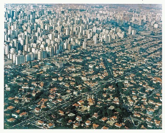
As of today, over 50% of the world’s population lives in urban areas, and by 2050, this urban population will almost double in size, and 7 of 10 people in the world will live in cities. As cities have continued to grow and expand throughout history, a new vocabulary has also emerged, often to better communicate the scale of urban living in a relatively contemporary context. One such example is the term megalopolis – typically defined as a network of large cities that have been interconnected with surrounding metropolitan areas by infrastructure or transportation. In effect, it’s a region perceived as an encompassing urban area, within which there is a constant flow of commerce and migration.
Envision your ideal neighborhood. Maybe it’s on a cul-de-sac in the suburbs, where every neighbor has a well-manicured lawn, a two-car garage, and everyone gives each other a friendly wave on their way to work. Or maybe you live in a high-rise building in a dense urban center, where you take public transit to the office five days a week and say hello to your doorman on your way out. Whatever your neighborhood might look like, there’s always a sense of wanting to know the people who live around your- or at least an unspoken reliance on one another to ensure that your surroundings are safe. What happens when technology brings you and your neighbors together to report on local happenings? Is it a good thing, or does it create a vigilante situation gone awry?
A few days ago, the world gathered at Sharm El Sheik, Egypt, for its annual climate change summit: COP27. Like the rest of Africa, Nigeria is represented by its retinue of bureaucrats, climate advocates, and other interest groups. Since the last meeting in Scotland (COP26), Nigeria signed the Climate Change Act into law, setting a target of attaining net-zero greenhouse gas emissions between 2050 and 2070. In the interim, Nigeria has developed an ambitious energy plan that would see it transition from fossil fuels to renewable energy, using its vast reserve of natural gas as a hedge. The country is at the forefront of the African Carbon Markets Initiative and plans to raise at least $500 million from carbon crediting trading to offset emitted carbon.
https://www.archdaily.com/992422/nigerias-ambitious-climate-agenda-and-its-misplaced-fixation-on-carbon-footprintMathias Agbo, Jr.
“Art aims to represent not the outward appearance of things, but their inward significance”, Greek polymath Aristotle remarked. Public art in cities worldwide seeks to pursue this aim by offering a sense of meaning and identification to its residents. Taking the form of murals, installations, sculptures, and statues, public art engages with audiences outside of museums and in the public realm. This art presents a democratic manner of collectively redefining concepts like community, identity, and social engagement.
A famous skyline can evoke rich associations and unleash imagination, but the real experience of a city is in its streets. Early humans evolved to see the first 20 feet in front, above, and around them so they could identify potential threats in the landscape. In our modern urban environment, this is still how we experience buildings and places. While aerial views and Google Earth imagery are useful for reference, the main experience of the outside of a building is what we pass by on the street, up to about the second or third story. The height of a building doesn’t necessarily matter if the street experience is rich and accessible.
https://www.archdaily.com/990889/activating-the-edges-how-to-create-lively-active-streetsAmanda Loper, Daniel Simons, David Baker
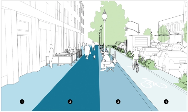
Future planning methods for sidewalks and public transit space. Image via Global Designing Cities Initiative
Whether you live in an urban, suburban, or rural area, there’s a good chance that using a sidewalk, in some capacity, is part of your everyday routine. Whether crossing over a sidewalk to get to your car in a parking lot or walking several blocks on your commute to your office downtown, sidewalks are critical for creating safe places for pedestrians away from the streets. But what happens when cities don’t take ownership over sidewalk maintenance, and they’re left to be protected by the people who just use them?
Dubrovnik, Croatia. Drone photo by @spencerdavisphoto
Some of the most characteristic features of city squares are related to the presence of people in the space and the purposes they are given, such as places for socializing, sports, tourism, and demonstrations. These different uses, often not foreseen in the project, are closely associated with the ground level, where people can walk around and experience the space. Viewed from an aerial perspective, on the other hand, squares can reveal other aspects related to their architectural design and their placement in the urban context.
The passage of the Biden Administration’s climate change package, the so-called “Inflation Reduction Act,” has predictably split along partisan lines, with Republicans characterizing the bill as an act of reckless government spending, certain to raise taxes and fuel further inflation. But does this act really represent reckless spending? The legislation authorizes $430 billion in spending, the bulk of which—more than $300 billion—is earmarked for tax credits; other spending, and initiatives aimed at stimulating the clean energy economy; and reducing carbon emissions. (The bill also allows Medicare to negotiate prices with drug companies for certain expensive drugs.) The bill is funded in part by a 15% minimum tax on large corporations and an excise tax on companies that repurchase shares of their own stock. Given the scope of the problem, and the escalating future costs of climate inaction, this legislation is an exceedingly modest, but very necessary, first step.
https://www.archdaily.com/988604/its-time-to-be-honest-about-the-impending-costs-of-climate-changeMartin C. Pedersen, Steven Bingler
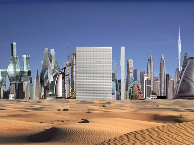
Rem Koolhaas, co-founder of Office for Metropolitan Architecture (OMA), receiver of the Pritzker Prize Award in 2000, and leading urban theorist, was one of the first to question the high-rise phenomenon and its influence on city transformation. Particularly intrigued by the Gulf region and the urban ambitions of this area, in 2009, during the 9th edition of the Sharjah Biennial, he delivered a lecture on the potential of re-inventing urbanization in the Emirates.
On the occasion of the golden jubilee of UAE, marking 50 years since the Emirates were founded in 1971, 50U, published by Archis explores the different developments in the Gulf, this region that “witnessed the transformation of a partly nomadic, partly town-based community into a globally active metropolitan society”. After Al Manakh, in 2007, followed in 2010 by Al Manakh Cont’d, 50U tells the story of the UAE through 50 portraits of people, plants, and places. The book also shares an excerpt of Koolhaas’ 2009 talk that reflects on contemporary conditions, focusing specifically on his reading of Dubai, his architectural involvement as well as his future urban predictions.


 license.")