1. ArchDaily
  2. Urban Planning

Urban Planning: The Latest Architecture and News

Slum Rehabilitation Promise to Mumbai's 20 Million

Subscriber Access | 
Slum Rehabilitation Promise to Mumbai's 20 Million - Image 3 of 4
Aerial View of Mumbai; Courtesy of Flickr User Cactus Bones; Licensed via Creative Commons

Slums, shanty-towns, favelas - they are all products of an exploding migration from rural to urban areas. Over the last half century, people living in or near metropolises has risen in proportion to the global population. Migrations from rural areas to urban areas have grown exponentially as cities have developed into hubs of economic activity and job growth promising new opportunities for social mobility and education. Yet, with all these perceptions holding fast, many people who choose to migrate find themselves in the difficult circumstances of integrating into an environment without the proper resources to accommodate the growing population. Cities, for example, like Mumbai, India's largest city and 11th on the list as of 2012 with a population of an estimated 20.5 million. According to a New York Times article from 2011, about 60% of that number live in the makeshift dwellings that now occupy lucrative land for Mumbai's developers.

More to come after the break.
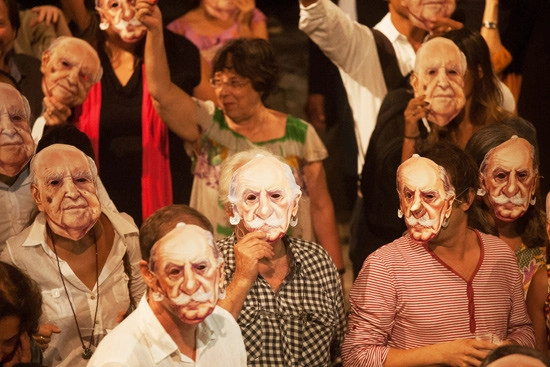
In Niemeyer and Costa Masks, Architects Protest the City of Brasilia

Wearing masks with the faces of Oscar Niemeyer and Lúcio Costa, architects and urban planners swarmed the 50th Annual IAB (Institute of Architects of Brazil) Awards in Rio de Janeiro this week. The architects were protesting a contract the city government of Brasilia struck with a Singaporean firm to create an urban masterplan outlining the next 50 years of Brasilia's future.

Our Ideal City? Seen through the eyes of the Pacific West Coast.

Our Ideal City? Seen through the eyes of the Pacific West Coast. - Featured Image
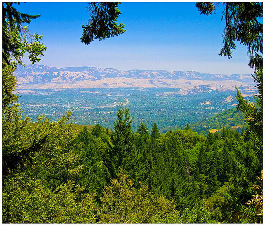
View of Silicon Valley via Flickr user Shootyoureyeout. Used under Creative Commons

As most New Yorkers know, people are willing to shell out a hefty sum to live in a place where work and play are right around the corner from each other. But as the article by Ken Layne in The Awl points out, the west coast is a somewhat different place. UNLIKE New York City, which is crowded with restaurants, bars, and entertainment, as well as offices, design firms and businesses; Silicon Valley, which caters to programmers and tech companies that hire at $100k a year, offers few of the amenities that a nearby town like San Francisco does. So, Layne concludes, residents are willing to spend hours of their day making their way into the fortressed office parks of Silicon Valley, flanked by parking lots and boulevards, just to have a cultural reprieve to call home.

High Line-Inspired Park proposed in Queens

Subscriber Access | 
High Line-Inspired Park proposed in Queens - Image 2 of 4
Rockaway Rail Branch of the LIRR; Photos Courtesy of Friends of the Queensway © 2012

When plans for the High Line were first revealed it made quite an impression on the design community. The converted elevated rail line, long abandoned by New York City, was threatened by demolition until a group of activists fought for its revival and helped transform it into one of the most renowned public spaces in Manhattan. Now Queens, a borough with its own abandoned infrastructure is on its way to redeveloping the land for its own version of the High Line, to be known as the Queensway Cultural Gateway.

In late December, the Trust for Public Land announced that New York Governor Andrew Cuomo has awarded a $467,000 grant to the organization to begin a feasibility study on the 3.5 mile Long Island rail line. Early proposals reveal a new pedestrian and bike path, public green space and a cultural gateway that will celebrate Queens’ diversity in art, sculpture and food, serving the 250,000 residents that live in the neighborhoods along the route, which include Rego Park, Forest Hills, Richmond Hill, Ozone Park and Forest Park.

Join us after the break for more.

Local Solutions: Floating Schools in Bangladesh

Subscriber Access | 
Local Solutions: Floating Schools in Bangladesh - Image 5 of 4
© Joseph A Ferris III

In Bangladesh, where rising sea levels are having profound effects on the landscape, one nonprofit organization called Shidhulai Swanirvar Sangstha run by architect Mohammed Rezwan is fighting back by adapting, a true quality of resilience. Rising water levels and the tumultuous climate is displacing people by the thousands; a projected 20% of Bangladesh is expected to be covered in water within twenty years. For a country that is one of the densest populated state on the planet, this figure has disastrous consequences for a population that has limited access to fresh water, food, and medicine. In response to these conditions, Shidhulai has focused on providing education, training and care against the odds of climate change by adapting to the altered landscape: moving schools and community centers onto the water – on boats.

Trans Ganga Masterplan Proposal / Studio Symbiosis

Subscriber Access | 
Trans Ganga Masterplan Proposal / Studio Symbiosis - Image 14 of 4
Courtesy of Studio Symbiosis

Spread across 1156 acres, the proposal for the Trans Ganga Masterplan by Studio Symbiosis is envisioned as an iconic city on the banks of Ganga, aimed at being a self sufficient sustainable city. Developed as a mixed use project, this will provide the most influential and dominant context for the master plan. More images and architects’ description after the break.

KPF Releases Masterplan for Chinese City Built From Scratch

Subscriber Access | 
KPF Releases Masterplan for Chinese City Built From Scratch  - Image 3 of 4
Courtesy of Kohn Pedersen Fox Associates (KPF)

International architecture firm Kohn Pedersen Fox Associates (KPF) recently announced that their design for the 120 million square foot master plan for Meixi Lake in Changsha, China is being realized. A new city in the West Changsha Pioneer Zone in Hunan Province, Meixi Lake is centered around a 3.85 kilometer‐long lake. Upon completion, the city will be home to 180,000 inhabitants, and will provide residents, workers and visitors sustainable neighborhoods for living, working, recreation, culture and entertainment. More images and architects’ press release after the break.

Brasilia Government Forges Controversial Contract with Singapore

Brasilia Government Forges Controversial Contract with Singapore - Featured Image
Aerial View of Brasilia: Capital of Brazil

One of the most talked-about topics of the XXIV Pan American Congress of Architects (XXIV CPA), which took place this November in Maceió, Brazil, was the Brazilian Government’s controversial move to contract consulting company Jurong, based in Singapore, with designing a new Masterplan for Brasilia.

Jurong’s "Brasilia Plan 2060,” which was chosen by the government with no outside participation or input, was criticized not only by Brazilian architects and urban planners, but by the majority of American and European professionals present at the XXIV CPA.

President of the UIA (International Union of Architects), Albert Dubler, stressed that community participation must be a crucial part of any wide-scale urban planning endeavor such as this. "We can not solve the problems of Brasilia without consulting the public. You need governance. I cannot imagine how this dialogue will happen with Singapore.” Dubler continued: “To have an idea represents 5% of a project. The design,10%. But 85% of any project is to discuss it with people - to convince the public."

Bloomberg Announces Plan For Downtown Brooklyn

Subscriber Access | 
Bloomberg Announces Plan For Downtown Brooklyn - Featured Image
32-Story Tower at Lafayette and Ashland, Courtesy of TEN Arquitectos. Via The Architect's Newspaper

In recent years Downtown Brooklyn has become somewhat of a hub of cultural activity.  Just past the triangular intersection of Flatbush Ave and Fulton Street, a high density of cultural buildings, expansive retail, and entertainment exists.  Mayor Michael Bloomberg of NYC announced in late November that the city and private companies will be partnering to produce three new projects in this area that will bring affordable housing and additional cultural and community spaces to Downtown Brooklyn.  This last city-owned parcel will be developed into mixed use facilities: a 515,000 square foot building at Fulton St, Rockwell Place and Ashland Place; a 32-story mixed use building on Flatbush and Lafayette to be designed by Enrique Norten of TEN Arquitectos and a third building currently in the RFP stage of development at Ashland Place and Lafayette.

Join us after the break for more.

Sao Paulo’s New Green Urban Planning Policy

Subscriber Access | 
Sao Paulo’s New Green Urban Planning Policy - Featured Image
istockphoto.com

The new Água Espraiada Operação Urbana urban planning program in Sao Paulo has taken a major approach to sustainability. With this plan in action, the Rochaverá Corporate Towers, a high profile mixed residential, office, and shopping complex, is a great example. The recently built project is located at a former industrial area along the Pinheiros River Basin. This enormous 1.2-million-square-foot development, designed by Aflalo and Gasperini Architects, was built to be highly energy efficient, control water usage, cut greenhouse gas emissions, and ease traffic congestion. With the success of the mentioned project, we can begin to ask ourselves, ‘How can a development accomplish all of those objectives?’ Start with urban planning that mitigates sprawl, one of biggest threats to the planet today. More information after the break.

Toronto's Anti-City Mayor Ousted

Toronto's Anti-City Mayor Ousted - Featured Image
OccupyToronto: Evict Rob Ford March (November 19, 2011). Photo via Flickr User CC Jackman Ciu. Used under Creative Commons

Rob Ford, the Toronto Mayor famous for making enemies of "urban thinkers, designers and practitioners," has been ousted from office for violating a conflict-of-interest act (he spoke and voted on a matter which allowed his own Football Foundation to financially benefit).

Masterplan for Hudson Square Streetscape Improvements / Mathews Nielsen Landscape Architects

Subscriber Access | 
Masterplan for Hudson Square Streetscape Improvements / Mathews Nielsen Landscape Architects - Image 7 of 4
© 2012 Hudson Square Connection Rendering by Mathews Nielsen Landscape Architects

Mathews Nielsen Landscape Architects shared with us their design for the streetscape masterplan for Hudson Square in Manhattan, New York. Designed to transform the district’s public realm into a socially, economically, and environmentally sustainable neighborhood, the project will serve area workers and, eventually, residents. The masterplan creates a pedestrian-focused district accessible from all directions and adjacent neighborhoods—including SoHo, TriBeCa, and Greenwich Village—that coordinates the needs of the Holland Tunnel, a regional transportation facility, with those of the re-imagined neighborhood. More images and architects’ description after the break.

North Point Harbour Urban Planning Concept Winning Proposal / Chris Y. H. Chan + Stephanie M. L. Tan

Subscriber Access | 
North Point Harbour Urban Planning Concept Winning Proposal / Chris Y. H. Chan + Stephanie M. L. Tan - Featured Image
Courtesy of Chris Y. H. Chan + Stephanie M. L. Tan

This design for the North Point waterfront redevelopment, which won the first prize in the competition, proposes an “organic network” of forms for the site. Designed by Chris Y. H. Chan + Stephanie M. L. Tan, the project approach is based on the study of the adjacent “community street” – Chun Yeung St., which should have human life and the life of dwellers establishing the community. In this project, they aim to transform the Chun Yeung St’s urban model as part of an organic ecology. This model could affect the North Point district to become a more sustainable urban model. More images and architects’ description after the break.

Almazan Main Square / ch+qs arquitectos

Almazan Main Square / ch+qs arquitectos - Public SpaceAlmazan Main Square / ch+qs arquitectos - Public SpaceAlmazan Main Square / ch+qs arquitectos - Public SpaceAlmazan Main Square / ch+qs arquitectos - Public SpaceAlmazan Main Square / ch+qs arquitectos - More Images+ 24

Hudson Yards' Long Awaited Makeover

Subscriber Access | 
Hudson Yards' Long Awaited Makeover - Image 4 of 4
Photo: Rendering by Visualhouse

The west side of midtown Manhattan is probably one of the more unexplored areas of New York City by residents and tourists alike. Aside from the Jacob Javits Center, and the different programs off of the Hudson River Parkway that runs parallel to the waterfront, there is very little reason to walk through this industry – and infrastructure – dominated expanse of land full of manufacturers, body shops, parking facilities and vacant lots. The NYC government and various agencies, aware of the lost potential of this area, began hatching plans in 2001 to develop this 48-block, 26-acre section, bound by 43rd Street to the North, 8th Ave to the East, 30th Street to the South and the West Side Highway to the West.

The new Hudson Yards, NYC’s largest development, will be a feat of collaboration between many agencies and designers. The result will be 26 million square feet of new office development, 20,000 units of housing, 2 million square feet of retail, and 3 million square feet of hotel space, mixed use development featuring cultural and parking uses, 12 acres of public open space, a new public school and an extension of a subway line the 7 that currently terminates at Times Square-42nd Street, reintroducing the otherwise infrastructurally isolated portion of the city back into the life of midtown Manhattan. All this for $800 million with up to $3 billion in public money.

Join us after the break for details and images.

Dutch Firm wins Best Future Concept with Smart Highways

Subscriber Access | 
Dutch Firm wins Best Future Concept with Smart Highways - Image 5 of 4
Courtesy of Studio Roosegaarde

Imagine driving down a road at night without street lights with the light-emitting road guiding your way. As the temperature outside drops the road starts to reveal images of ice crystals, signaling to you, the driver, that conditions are now icy and slippery. This futuristic concept may soon be a reality as Dutch design firm Studio Roosegaarde and the engineers at Heijmans Infrastructure team up to develop “Smart Highways” – a design agenda for interactive, sustainable and safe roads. The concept won the two firms Best Future Concept at the Dutch Design Awards 2012. Join us after the break for more.

Post-Hurricane Sandy: Solutions for a Resilient City

Subscriber Access | 
Post-Hurricane Sandy: Solutions for a Resilient City - Featured Image
Hurricane Sandy damage north of Seaside, N.J. on Tuesday, Oct. 30, 2012. © Governor’s Office / Tim Larsen

In the wake of Hurricane Sandy, as communities band together to clean up the devastation and utility companies work tirelessly to restore the infrastructure that keeps New York City running, planners and policy makers are debating the next steps to making the city as resilient to natural disaster as we once thought it was. We have at our hands a range of options to debate and design and the political leverage to make some of these solutions a reality. The question now is, which option or combination of options is most suitable for protecting New York City and its boroughs? Follow us after the break for more.

Revitalization of the City of Andenne / Frédéric Haesevoets Architecture + Art and Build

Subscriber Access | 
Revitalization of the City of Andenne / Frédéric Haesevoets Architecture + Art and Build - Image 6 of 4
Courtesy of Frédéric Haesevoets Architecture

Located in the heart of Andenne, near the town square, the project by Frédéric Haesevoets Architecture + Art and Build focuses on the revitalization of the city center, to assure for the future a coherent urbanization. These future blocks will complete the existing urban fabric of the neighborhood which is booming. Carefully integrated, these blocks will fit into the urban fabric without attacking the city, on the contrary, they weave links with the surrounding streets by a sensitive treatment of the spaces. More images and architects’ description after the break.