1. ArchDaily
  2. Urbanism

Urbanism: The Latest Architecture and News

What's Stopping Urban Designers From Creating Walkable Neighborhoods From Scratch?

What's Stopping Urban Designers From Creating Walkable Neighborhoods From Scratch? - Image 1 of 4
A walkable street in Washington, DC. Image © Flickr user dewita-soeharjono licensed under CC BY 2.0

This article was originally published by Common Edge as "Why Can’t We Create Brand New Walkable Communities?"

I have lived in neighborhoods where you can walk around, to a store, a movie, a restaurant, for 40 years, counting my college days. I grew up in a ranch house with a driveway, but came to adulthood in foot-based parts of cities.

Others have also rediscovered the joys and benefits of walkable places. They have done this first in a trickle, then in a flood. While in total numbers it may still be a minority taste, it’s a fashionable taste now, one heralded in movies and TV shows. Fewer people aspire to live in the big house with the three-car garage.

How the Layout of Urban "Cells" Affects The Function and Success of Neighborhoods

As urban areas develop, each city forms a unique structural logic. With this structure usually conceived on an ad-hoc basis, political terms such as “metropolitan area” and “neighborhood” are not always useful when analyzing and comparing the performance of cities. In a quest for new analytical tools, Robin Renner has devised an anatomically-based classification system in his new book Urban Being: Anatomy & Identity of the City. Through a thoughtful investigation of existing urban areas from around the globe using satellite images and personal experiences, Urban Being offers an insight into how transportation networks and streetscapes can be best organized to promote a healthy metropolitan environment.

Renner’s analysis ranges from macro-regions that can even cross country borders to the defined spaces between arterial roads in cities, which he calls "urban cells." As the neighborhoods and units in which inhabitants reside, urban cells are important when examining the identity and efficiency of a city. They are defined by both their physical properties and the actions that take place inside of them. Below is a small sample of how Renner analyzes urban cells from the book.

How the Layout of Urban "Cells" Affects The Function and Success of Neighborhoods - Image 1 of 4How the Layout of Urban "Cells" Affects The Function and Success of Neighborhoods - Image 2 of 4How the Layout of Urban "Cells" Affects The Function and Success of Neighborhoods - Image 3 of 4How the Layout of Urban "Cells" Affects The Function and Success of Neighborhoods - Image 4 of 4How the Layout of Urban Cells Affects The Function and Success of Neighborhoods - More Images+ 1

This Unique New Technology Hopes to Turn Your City’s Streets Into Your News Homepage

The people of Manchester, UK, recently gained access to an entirely new way to access local news and engage with their city: OtherWorld, a pilot news experiment from startup studio Like No Other and Google’s Digital News Initiative. OtherWorld uses Bluetooth and cutting-edge beacon technology to deliver geo-located news directly to your smartphone for free, without installing an app. Referred to on the OtherWorld website as “living media,” as users walk around the city and pass by story locations, a silent notification will pop up on their phones, disappearing again as they walk out of range. Because the news you see on OtherWorld is directly related to the space you’re currently occupying, the system ensures that the news you’ll see is relevant to you. This unobtrusive method allows users to choose whether and how they will engage as well as adding an evanescent, elusive quality to the stories; you could walk right by and miss one if you aren’t paying attention.

In this way, OtherWorld illustrates the layers of our cities that are often invisible to us, bringing them into focus and allowing a deeper level of exploration into even a familiar city neighborhood. Focusing on stories that involve a real-world experience, users could become aware of an event nearby, a volunteer opportunity, a public meeting, or any number of other possibilities—thereby involving themselves in the public space and public realm in a way they would not have otherwise been able to.

5 Online Resources That Explore The Intersection Between Landscape, Architecture and Culture

At times, Landscape design lacks proper consideration or its overlooked within architecture, as a result of current but preconceived notions within architectural practice and education that privilege building over site, or the constructed over the existing. While at face value, landscape is treated as an abject and constant entity of sorts, the reality is that it possesses a layered complexity of patterns and ecosystems, much of which is increasingly impacted by our own actions, more significantly than what meets the eye.

At the same time, the definition of landscape is constantly evolving to encompass a greater number of influences and factors. We have cultural, built and ecological landscapes, which influence one another and come about as a result of the intersection between the architecture and the environment that we are presented with. As a result, it is important to view terrain in a more holistic light, acknowledging its ecological underpinnings and well as the anthropological effects it is subject to, both physically and theoretically. Here is a list of five online resources, which investigate the interdisciplinary nature of landscape design and its relation to architecture and culture.

Learn to Design an Urban Block With This Set of 50 Cards

We know perfectly well that learning in architecture and urbanism can take on multiple forms. Just think of all the modeling, drawing, plans, theoretical classes, workshops, 3D models and even virtual reality exercises. In this same line, the team at a+t architecture publishers have put together a collection of cards that seek to facilitate the designing of an urban block with 50 design styles.

Each card measures 13 x 8 cm and is printed on both sides, with a version in English and Spanish. Also, each design includes its axonometric profile, general layout, shade patterns, use coefficient and total built space in both meters and feet. 

Jan Gehl: "The Modern Movement Put an End to the Human Scale"

On Thursday 29 of June, Jan Gehl the Danish architect and urban planner, spoke at the Conference “Thinking urban: cities for people” organised by UN-Habitat and the Official Architects College of Madrid (COAM as it is abbreviated in Spanish) about the urban transformations that have occurred in Copenhagen as a result of the errors of the modernist movement and the challenges facing the cities in the 21st century.

In a prior discussion with José María Ezquiaga (dean of COAM), and José Manuel Calvo (councilor of the Sustainable Development Area at the Madrid city council) at the Conference, Gehl highlighted the urban paradigm at the time of his student years, which is referred to as the Brasilia syndrome. 

ReSITE 2017’s “The In/Visible City” Conference Unveils the Infrastructural Heart of Urbanism

Now in its sixth year in its home city of Prague, reSITE is a conference that has consistently taken a broad view of urban issues, bringing together the largest concentration of the world’s top architects, urbanists, urban planners, landscape architects, and economists under umbrella topics such as Cities in Migration (2016), The Sharing City (2015), and Cities and Landscapes of the New Economy (2014). However, when it comes to events like this, such broad-ranging ambition can be a double-edged sword, flattening and obscuring the nitty gritty details of complex issues. Perhaps reflecting a concern that cities and the challenges they face be seen in full, reSITE 2017’s chosen theme was In/Visible City.

That particular lens reflects a shift in recent years for events such as this to bring into focus that which has typically remained firmly out of view: infrastructure. An allusion to the technical was manifest in the conference’s visual identity: a human heart, with pipe-like arteries and vegetation growing in between the cracks. The heart is to the body like infrastructure is to the city – but just as the body is much more than its circulatory system, the infrastructure cities depend upon is not limited to the obvious, billion-dollar construction projects that make headlines. Urban infrastructure spans all scales and numerous disciplines, ranging from design details to the small print in city policy. In/visible City brought forth the invisible features that give shape to the visible city demonstrating that cultural vitality, social fabric and citizen participation are infrastructural as well.

Three Principles of Architecture as Revealed by Italo Calvino's 'Invisible Cities'

Ah, Invisible Cities. For many of us, Italo Calvino’s 1972 novel reserves a dear place in our libraries, architectural or otherwise, for its vivid recollections of cities and their curiosities, courtesy of a certain Marco Polo as he narrates to Kublai Khan. And while the book doesn’t specifically fit the bill in terms of conventional architectural writing, it resists an overall categorisation at all, instead superseding the distillation of the cities it contains into distinct boundaries and purposes.

For though there is a certain kind of sensory appeal that is captured in the details of places, the real beauty of Invisible Cities lies in the masking of underlying notions of time, identity and language within these details – a feat that is skillfully accomplished by both Marco and Calvino. With this in mind, here are three of many such principles, as revealed by the layered narrative of Invisible Cities.

Striking Overhead Images That Reveal the Inequality of Modern Cities

It is said that the world is increasingly developed when in fact it is, undeniably, more technological and globalized. However, it seems risky to talk about development when the advances do not appear everywhere or for all inhabitants.

In such an uneven picture, a select few of the global population enjoy these advances, while a huge number live below the poverty line.

Such contrasts often go unnoticed in the city's daily life, however, are set forth on a diptych relationship with the urban layout, being, at the same time the cause and consequence of deep marks in city design. In Brazil, for example, we have the slums and poor communities that contrast with the buildings and upper-middle-class homes architecture, designed and built with all the necessary resources.

How Photography Helped to Dehumanize Our Cities

This article was originally published on Common Edge as "How Photography Profoundly Reshaped Our Ideas About Cities."

Early in the 19th century, an invention arrived that would change the form and function of cities for generations.

Like all new technologies, it started out rudimentary, expensive, and nearly ineffectual. But it caught many imaginations and developed dramatically, eventually reaching the point of mass accessibility. Soon enough, it took aim at the public realm, with consequences that were indirect and unintended yet profound.

It reconfigured streets. It influenced the height of buildings. It altered foot traffic. It recast the relationship between buildings and streets. It changed how people felt about their cities and changed their points of reference. It turned cities into abstractions and, in some ways, turned city-dwellers against each other. Its influence nearly complete by the close of World War I, the invention has remained fundamentally unchanged, and is still universally celebrated, to this day.

All this with the press of a button.

Stood in Splendid Isolation, Questions Are Raised About Apple's Cupertino Campus

The "Spaceship" has landed and the dust, it appears, is starting to settle. In an article by Adam Rogers, which follows Wired's exclusive breakdown of the new Apple Campus in Cupertino, California, a convincing case is put forward against its design and wider masterplan. "You can’t understand a building without looking at what’s around it," Rogers argues – and most, including its architects, Foster+Partners, would surely be inclined to agree.

Whether you call it the Ring (too JRR Tolkien), the Death Star (too George Lucas), or the Spaceship (too Buckminster Fuller), something has alighted in Cupertino. And no one could possibly question the elegance of its design and architecture. This building is $5 billion and 2.8 million square feet of Steve Jobsian-Jony Ivesian-Norman Fosterian genius.

Citymapper, World-Renowned Urban Mobility App, Launches London's First Pop-Up Bus Route

Citymapper, World-Renowned Urban Mobility App, Launches London's First Pop-Up Bus Route - Image 4 of 4
Citymapper's new buses in central London. Image Courtesy of Citymapper

Citymapper, which is just over five years old, has become the go-to mobility app for the majority of the world's major cities. It's strength lies in its accuracy and integration: the app parses local data and always seems to deliver the fastest route, even in comparison to its leviathan, data-rich competitors – Google Maps and Apple Maps. Having always focused their attention on public transport, as opposed to cars and taxis, Citymapper has become embedded into the way large amounts of urbanites navigate cities both familiar and foreign. As of today, they are building buses—and bus routes—of their own.

Citymapper, World-Renowned Urban Mobility App, Launches London's First Pop-Up Bus Route - Featured ImageCitymapper, World-Renowned Urban Mobility App, Launches London's First Pop-Up Bus Route - Image 1 of 4Citymapper, World-Renowned Urban Mobility App, Launches London's First Pop-Up Bus Route - Image 2 of 4Citymapper, World-Renowned Urban Mobility App, Launches London's First Pop-Up Bus Route - Image 3 of 4Citymapper, World-Renowned Urban Mobility App, Launches London's First Pop-Up Bus Route - More Images+ 3

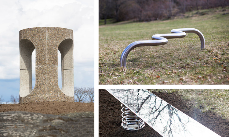
In the Swedish City of Järfälla, Ten Radical "Superbenches" Are Unveiled as Community Incubators

Sweden is home to the world’s longest public bench. At 240 feet (around 72 meters) in length, the Långa Soffan (“long sofa”) was installed by the citizens of Oskarshamn in 1867 to overlook its rather unspectacular harbour, which opens toward the Baltic Sea. The function of this bench was not for passing time and taking in the coastal views, however; in times gone by it was rhythmically occupied by the wives of sailors awaiting their husband’s return from sea voyages. It allowed people to gather under a sense of common melancholy and collectively recall the smiles of their distant spouses before the ocean’s broad, blue canvas.

Korean Curiosity: Is Seoul Experiencing a "Neo-Brutalist Revival"?

Korean Curiosity: Is Seoul Experiencing a "Neo-Brutalist Revival"? - Image 15 of 4
© Raphael Olivier

During his frequent travels to Seoul, Hong Kong- and Singapore-based photographer Raphael Olivier noticed a new trend taking the South Korean capital: a crop of geometric, concrete buildings of all genres. He calls the new style Neo-Brutalism, after the modernist movement that proliferated in the late 1950s to 1970s, in which raw concrete was meant to express a truth and honesty. Olivier's observation led him to capture the phenomenon in a personal photo series—a photographic treasure trove of these projects which, when taken as a whole, uncovers a cross-section of this trend in the city's architecture.

Korean Curiosity: Is Seoul Experiencing a "Neo-Brutalist Revival"? - Image 1 of 4Korean Curiosity: Is Seoul Experiencing a "Neo-Brutalist Revival"? - Image 2 of 4Korean Curiosity: Is Seoul Experiencing a "Neo-Brutalist Revival"? - Image 3 of 4Korean Curiosity: Is Seoul Experiencing a "Neo-Brutalist Revival"? - Image 4 of 4Korean Curiosity: Is Seoul Experiencing a Neo-Brutalist Revival? - More Images+ 14

What can Latin America Learn From WOHA's Green Skyscrapers?

WOHA's first exhibition in Latin America, Garden City Mega City: WOHA's Urban Ecosystems presents over two decades of WOHA's international designs. With its inauguration at the Museum of the City of Mexico during the MEXTRÓPOLI International Festival of Architecture and City, the exhibition proposes the introduction of biodiversity and lively public spaces into vertical, climate-sensitive highrises within megalopolises.

The exhibition features sixteen intricate architectural models, an immersive video installation and large-scale drawings and images that show WOHA's proposals for vertical communities in the tropical megacities. PLANE-SITE documented the exhibition's opening along with the points of view of various MEXTRÓPOLI contributors and city officials.

11 Architecture, Design and Urbanism Podcasts to Start Listening to Now

It can sometimes feel as if the world is divided into two camps: those who do not listen to podcasts (probably because they don’t know what a podcast is) and those who listen to podcasts, love podcasts, and keep badgering their friends for recommendations so they can start listening to even more.

Unlike other media, it’s notoriously difficult to discover and share podcasts – even more so if you’re looking for a podcast on a niche subject like architecture, design or urbanism. To help you in your hour of need, Metropolis’ Vanessa Quirk (author of Guide to Podcasting) and ArchDaily’s James Taylor-Foster (whose silvery tones you may have heard on various architecture and design audio stories) have come together to compile this list of eleven podcasts you should subscribe to.

WOHA On Why High-Density Living Doesn't Mean Sacrificing Nice Things

As part of the MEXTRÓPOLI festival in Mexico City early last month, Singapore-based firm WOHA debuted their first exhibition in the Latin America, GARDEN CITY MEGA CITY. WOHA's architecture introduces biodiversity into public spaces, turning high-rise courtyards and hallways into teeming community assets. In this exhibition, the architects show how their work has addressed both climate change and the social challenges that occur as a result of rapid (upward) urban development.

Dominique Perrault Proposes "Island Monument" Plan For the Île de la Cité in Paris

Dominique Perrault Proposes "Island Monument" Plan For the Île de la Cité in Paris - Image 7 of 4
© Dominique Perrault Architecture / ADAGP

One of two islands in the Parisian Seine, the Île de la Cité is largely known to tourists as little more than the location of such popular destinations as the Notre Dame Cathedral and the Sainte Chapelle—a fate that belies the island's 2000-year history as the center of Paris. However, now there are plans underway to restore the whole island to its former importance: under Philippe Bélaval, the French Centre for National Monuments has selected Dominique Perrault Architecture to design a 25-year masterplan, titled Mission Île de la Cité, to bring back the island’s relevance as something more than a dissonant collection of tourist destinations.

Dominique Perrault Proposes "Island Monument" Plan For the Île de la Cité in Paris - Image 1 of 4Dominique Perrault Proposes "Island Monument" Plan For the Île de la Cité in Paris - Image 2 of 4Dominique Perrault Proposes "Island Monument" Plan For the Île de la Cité in Paris - Image 3 of 4Dominique Perrault Proposes "Island Monument" Plan For the Île de la Cité in Paris - Image 4 of 4Dominique Perrault Proposes Island Monument Plan For the Île de la Cité in Paris - More Images+ 13