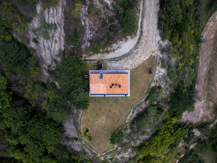
Aerial Photography of Houses in Ecuador: Visualizing a Building From Above

Capturing aerial photographs allows raising awareness of a project feature usually complex to capture using traditional methods. Based on the technological opportunities offered by small unmanned aerial vehicles (UAVs), commonly called drones, architecture photographers have begun to explore new ways of capturing a project in order to expose design decisions such as implantation, dialogue with the environment, or the relationship with nearby buildings.

Being able to convey the architectural relationship between a building and its context is something that has aroused the interest of architects even before digital photography was not yet available as a massive tool today is.

Commonly represented on drawings as “floor plan, this type of visualization allowed to explain information about the environment and, at the same time, give clues about the programmatic organization of the plan.

Can you decode some design strategies by viewing only the aerial photos of a project? Can you guess how the building is oriented according to the shadows cast by its volume? Where does it close and where does it open? How does it relate to the existing roads and buildings? How do you position yourself in front of the landscape? To illustrate with some examples, we present a selection of houses across Ecuador showcased through aerial photography taken by drones.

Cumbaya House / Diego Guayasamin Arquitectos

  • Location: Quito, Ecuador
  • Year: 2016

Aerial Photography of Houses in Ecuador: Visualizing a Building From Above - Image 5 of 11
Cumbaya House / Diego Guayasamin Arquitectos. Image © Sebastián Crespo

Ortega House / Estudio A0

  • Location: Sangolqui, Ecuador
  • Year: 2017

Aerial Photography of Houses in Ecuador: Visualizing a Building From Above - Image 4 of 11
Ortega House / Estudio A0. Image © Sebastián Crespo

Su House / Bernardo Bustamante Arquitectos

  • Location: Quito, Ecuador
  • Year: 2017

Aerial Photography of Houses in Ecuador: Visualizing a Building From Above - Image 9 of 11
Su House / Bernardo Bustamante Arquitectos. Image © BICUBIK

El Cortijo House / Felipe Assadi Arquitectos

  • Location: Samborondon, Ecuador
  • Year: 2018

Aerial Photography of Houses in Ecuador: Visualizing a Building From Above - Image 3 of 11
El Cortijo House / Felipe Assadi Arquitectos. Image © Fernando Alda

Casa Tanda / ESEcolectivo Arquitectos

  • Location: Tabacundo, Ecuador
  • Year: 2018

Aerial Photography of Houses in Ecuador: Visualizing a Building From Above - Image 10 of 11
Casa Tanda / ESEcolectivo Arquitectos. Image © Andrés Villota Pelusa

Observatory Reform Cóndor Huachana / La cabina de la curiosidad - Daniel Moreno Flores + Marie Combette

  • Location: Quito, Ecuador
  • Year: 2019

Aerial Photography of Houses in Ecuador: Visualizing a Building From Above - Image 11 of 11
Observatory Reform Cóndor Huachana / La cabina de la curiosidad - Daniel Moreno Flores + Marie Combette. Image © Andrés Villota Pelusa

D4 House / Edwin Hurtado + Holger Cuadrado

  • Location: Loja, Ecuador
  • Year: 2020

Aerial Photography of Houses in Ecuador: Visualizing a Building From Above - Image 6 of 11
D4 House / Edwin Hurtado + Holger Cuadrado. Image © JAG Studio

Muta House / Emilio López Arquitecto

  • Location: Quito, Ecuador
  • Year: 2020

Aerial Photography of Houses in Ecuador: Visualizing a Building From Above - Image 7 of 11
Muta House / Emilio López Arquitecto. Image © JAG Studio

Manglaralto House / Berru Arquitectos

  • Location: Montañita, Ecuador
  • Year: 2020

Aerial Photography of Houses in Ecuador: Visualizing a Building From Above - Image 2 of 11
Manglaralto House / Berru Arquitectos. Image © JAG Studio

Native House / David Regalado Arquitectura

  • Location: Malacatos, Ecuador
  • Year: 2020

Aerial Photography of Houses in Ecuador: Visualizing a Building From Above - Image 8 of 11
Native House / David Regalado Arquitectura. Image © JAG Studio

Discover aerial photography taken with drones and explore Architecture in Ecuador.

Image gallery

See allShow less
About this author
Cite: Maiztegui, Belén. "Aerial Photography of Houses in Ecuador: Visualizing a Building From Above" [10 Fotografías aéreas de casas en Ecuador: La importancia de visualizar una obra de arquitectura en su entorno] 09 Aug 2021. ArchDaily. (Trans. Valencia, Nicolás) Accessed . <https://www.archdaily.com/965631/aerial-photography-of-houses-in-ecuador-visualizing-a-building-from-above> ISSN 0719-8884

Native House / David Regalado Arquitectura. Image © JAG Studio

厄瓜多尔房屋航拍:空中建筑观察

You've started following your first account!

Did you know?

You'll now receive updates based on what you follow! Personalize your stream and start following your favorite authors, offices and users.