For the past fifteen years, global headlines have depicted, through harrowing imagery, the effects of war on cities across the Middle East. An inevitable fracturing of law and order leads to an explosion of crime which we imagine could not be tolerated in a region at peace. However, when cities in war zones are set aside, an overwhelming yet underreported narrative emerges – 86% of the world’s most dangerous cities are in Latin America and the Caribbean.
Citymapper, which is just over five years old, has become the go-to mobility app for the majority of the world's major cities. It's strength lies in its accuracy and integration: the app parses local data and always seems to deliver the fastest route, even in comparison to its leviathan, data-rich competitors – Google Maps and Apple Maps. Having always focused their attention on public transport, as opposed to cars and taxis, Citymapper has become embedded into the way large amounts of urbanites navigate cities both familiar and foreign. As of today, they are building buses—and bus routes—of their own.
Though the idea of a vacation in Mexico usually brings to mind images of margaritas on white-sand beaches, it seems the country is slowly but surely gaining recognition in other aspects as well. Among the most populated urban cities in Latin America and the world – not to mention The New York Times' number one "Place to Go in 2016" – Mexico City offers a particular cultural diversity evident both in its traditions and in its architecture. Considering it's the main tourist, educational, cultural, economic and political center of Mexico, it makes sense that it's the perfect scenario for the social encounters of its multicultural inhabitants and tourists.
The sites of architectural interest alone are worth the visit, with prehispanic, classic, modern and contemporary examples ranging from Juan O'Gorman and Luis Barragán to Felix Candela and David Chipperfield. Add to that the fact that its gastronomic scene has garnered much praise and attention in recent years, and you've got a perfect combo. Below is a carefully curated list of 30 sites that every architect should know and visit.
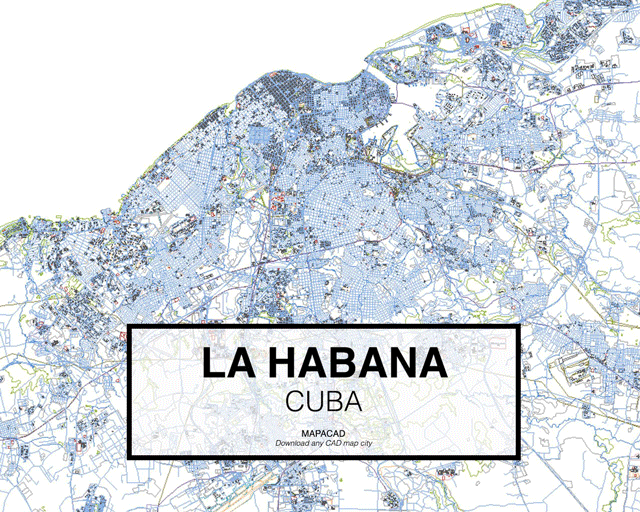
Mapacad is a website that offers downloads of .dwgs of dozens of cities. With 200 metropolises in their database, the founders have shared a set of their most-downloaded cities.
The files contain closed polyline layers for buildings, streets, highways, city limits, and geographical data--all ready for use in CAD programs like Autocad, Rhino, BricsCad and SketchUp.
The importance of public spaces in urban life is an issue that has been apparent since ancient Greece and is still with us today. Opportunities to meet and exchange ideas in these spaces are able to influence how the inhabitants participate in the development of their city, and occur in greater instances when public spaces are accessible to everyone.
However, in modern societies, the strategic role of these spaces has been limited. According to The City Fix, a blog on sustainable urban planning, one of the main reasons for this is the overabundance of automobiles. In fact, according to one study by the Brazilian Institute for Energy and the Environment, 70% of public spaces in urban centers are taken up by roadways and other spaces for cars, while car owners make up only around 20 to 40 percent of the city’s population.
How can public spaces be recovered to promote urban life? We discuss three important factors below.
Frank Lloyd Wright once described cities as both ‘our glory and our menace’. With more than half of the world’s population now living in cities, architects are becoming increasingly interested in their origins. Many fields of historical, geographical, and spatial research are devoted to exploring the evolution of cities, revealing a set of similarities across the globe. In a recent video, Wendover Productions described a common set of characteristics linking some of our largest cities, six of which we have outlined below.
Taking the six factors below into account, where is the perfect ‘world city’? Watch the video after the break:
https://www.archdaily.com/866821/the-origin-of-cities-six-reasons-for-their-locationNiall Patrick Walsh
The John S. and James L. Knight Foundation has announced the names of the 144 finalists in the 2017 edition of the Knight Cities Challenge, a nationwide call for innovative ideas aimed at transforming the organizations’ 26 member communities into more vibrant places to live and work. Open to innovators and designers from any field, the challenge requested submissions that responded to a simple prompt: What’s your best idea to make cities more successful?
Pedestrians, the most vulnerable users of road space, will now be more visible to drivers in the Netherlands with the inauguration of a new luminous pedestrian crossing this past November in Brummen, west of Amsterdam.
Designed by the Dutch firm Lighted Zebra Crossing, and installed free of charge for the municipality, this crossing makes pedestrians more visible at night or during bad weather. Each of the lines has two plates of lights that at night remain illuminated at all times and not only when there are people on them.
The latest publication of the National Association of City Transportation Officials, NACTO, is the "Transit Street Design Guide" in which tips and proposals are presented on how to improve streets through urban design.
The ideas are centered on prioritizing sustainable mobility so that both the member cities of the organization and those that have access to this document can improve their practices in relation to public spaces, mobility, and transportation.
Over the last few years, the way Americans move around has changed remarkably, especially among young people. Previously the automobile was people’s preferred, if not the only, option. Now they are choosing to walk, bike, or use public transport according to recent studies.
This difference in preferred transportation methods has generated many benefits not only for residents but also for cities, in both economic and social terms.
Building a highway in a city is often thought of as a solution to traffic congestion. However, the induced demand theory has shown that when drivers have more routes, they choose to continue using this medium instead of using public transport or a bicycle, and as a result, congestion doesn’t decrease.
As a result, some cities have chosen to remove spaces designated for cars and turn what was once a highway into urban parks and less congested streets.
Here we have six examples, some have already been completed, while a few are still under construction. To the surprise of some, most of the projects are in the US, which reflects that American designers are looking into further studying European transport policies.
Buenos Aires' contemporary urban landscape as we know it today provides a tempered mix of historical and recent construction projects. As one of the most beautiful cities in South America, it's wide boulevards and grand buildings, based on European models, have morphed to embrace the needs of a modern metropolis.
These images show just how profoundly time affects our cities (and how centuries-old foliage can powerfully transform spatial perception).
Browse the 20 interactive images of Buenos Aires before and after.
A recent article published in Nature makes a bold claim: we're analyzing our cities completely wrong. Professors David Wachsmuth, Aldana Cohen, and Hillary Angelo argue that, for too long, we have defined sustainability too narrowly, only looking at environmental impact on a neighborhood or city scale rather than a regional or global scale. As a result, we have measured our cities in ways that are inherently biased towards wealthy cities, and completely ignored the negative impacts our so-called "sustainable," post-industrial cities have on the rest of the world.Metropolis editor Vanessa Quirk spoke with Professor Wachsmuth to learn more about the unintended knock-on effects of going "green," the importance of consumption-based carbon counting, and why policy-makers should be more attentive to the effects of "environmental gentrification."
From the Cradle of Civilization in ancient Mesopotamia to the modern urban explosion in China, cities are among the most obvious and dramatic evidence of human existence. In a recent paper published in Scientific Data, a team led by Yale University researcher Meredith Reba mapped the emergence of cities between 3,700 BC and 2,000 AD based on when their populations were first recorded in historical accounts.
Taking the data from this study, Max Galka of Metrocosm has produced this fascinating animation showing the history of cities worldwide. "Most datasets available go back only a few years or decades at most. This is the first one I've seen that covers 6 millennia," Galka told CityLab. "I'm a big fan of history, so after reading the study, I thought it would be interesting to visualize the data and see if it offers some perspective." The steady flow of time may seem a little slow at first, but stick with it through the early BC years and the shifts in urban development start to get intriguing. And—spoiler alert—buckle up as you approach the 20th century.
Jericho, Palestinian Territories, 9,000 BC. Image Courtesy of Wikimedia User: Dr. Avishai Teicher Pikiwiki Israel licensed under CC BY 3.0
Have you ever wondered which are humanity's oldest cities? Matador Network has compiled a list of the world's ancient metropolises, and perhaps unsurprisingly, nearly all of them are within or adjacent to the Fertile Crescent, a moon-shaped region running from the Persian Gulf through what is today the south of Iraq, Syria, Lebanon, Jordan, Israel, and the Nile River Delta in Egypt. With settings that range from hamlets on the road less traveled, like Susa, Iran, and Sidon, Lebanon, to cities that hold international renown as trade and migratory crossroads, like Beirut and Damascus, these places share an ability to endure through the highs and lows of fortune and conflict. This factor of longevity is all the more remarkable considering that the youngest locales date from 3,000 BC and others extend back another 6,000 years.
Find the complete list of cities on Matador Network, here.
Urban95 Challenge: Designing Cities that support Healthy Child Development
Do you have an idea to improve the lives of young children in cities? How would you organise neighbourhoods, public space, green areas, housing, services and transportation? What else would you change or improve? The Bernard van Leer Foundation will invest in promising small projects that benefit young children in cities from the prenatal period up to the age of five. Applications are open to all organisations and individuals, from any country.
Many technological advancements have changed the way we design in the past 150 years, but perhaps none has had a greater impact than the invention of the passenger elevator. Prior to Elisha Otis’ design for the elevator safety brake in 1853, buildings rarely reached 7 stories. Since then, buildings have only been growing taller and taller. In 2009, the world’s tallest building, the Burj Khalifa, maxed out at 163 floors (serviced by Otis elevators). Though a century and half separates those milestones, in that time elevator technology has actually changed relatively little - until recently.
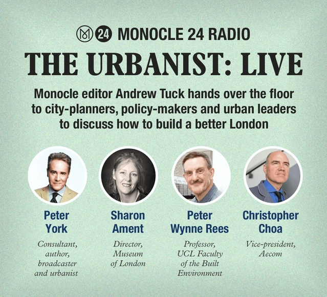
Join us for this special live episode of The Urbanist at our Marylebone HQ, where Monocle editor Andrew Tuck hands over the floor to city-planners, policy-makers and urban leaders to discuss how to build a better London. How would you fix the capital? We’ll look at transport, culture, housing, business, the night-time economy and much more. Be part of the debate following the election of the city’s new mayor.