Could Virtual Cities Make Our Real Cities Smarter?

This article, by Klaus Philipsen, FAIA originally appeared on his blog Community Architect.

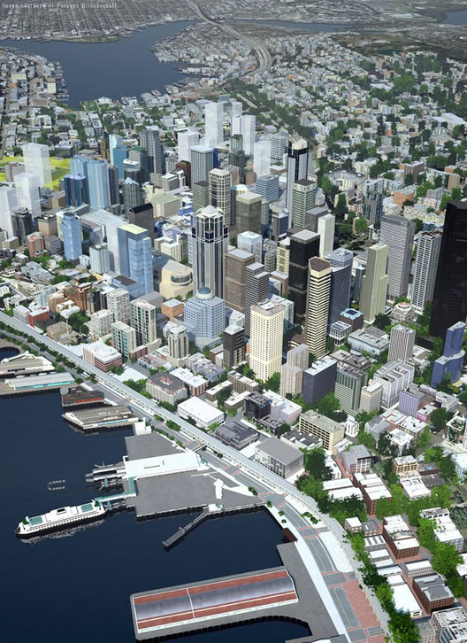
As BIM (Building Information Modeling) slowly finds broader acceptance in the architecture and engineering of individual buildings, perhaps it is time to consider the next scale: the city. Just like virtual models help us design and understand buildings and embed information, virtual city simulations could have an application in real city planning, allowing us to go from “flat” GIS to three dimensional information modeling that includes terrain, infrastructure, buildings and public spaces. Could virtual cities be the answer to "smart cities"? Find out after the break.

The Proposed Alaskan Way Tunnel. Image © Parsons Brinkerhoff

Example Seattle

Seattle clearly said yes. Or maybe it was just Autodesk who wants to sell software. Fact is, Seattle has built a smart 3-D model of much of its core area that does not only represent the real-life Seattle to an impressive level of look-alike but has loaded the 3-D model up with information about structures of all kinds. This works much like BIM does on the level of the individual building but is scaled up to the neighborhood and city level. Incredibly, the Seattle model even includes what is hidden from the eye: underground infrastructure. The Atlantic Cities published an article with an embedded video that showed the modeled Alaskan Way Viaduct in an earthquake and how it after some violent shakes pancaked and came crushing down. Alongside that calamity the video also showed buildings and power lines shaking and partially collapsing as well as fires erupting where gas lines broke. All this wasn't done for some fictional horror movie like King Kong climbing the Empire State Building but reportedly based on the actual engineering of these structures and an actual strong earthquake. Naturally, the video visualized neatly why Seattle should engage in the nation's second (after Boston) "big dig" which buries the Alaskan Way freeway in a huge bored underground tunnel.

Those who have been to Seattle know that as in Boston, the debate is about an elevated freeway separating downtown from the waterfront. While Boston's I-95 tunnel is completed and normal life has returned to the surface, Seattle's double-decker Alaskan Way is still up and running but their big dig has begun.

Vancouver model. Image © Dan Campbell

Visual models versus information modelling

Back to the "smart city" and to 3-D modelling: What could be more intriguing than to embed all that information that is currently flowing around in a thousand different channels in one place, the virtual model of the city? Built like the architect's BIM CAD such a model could accommodate all kinds of useful information such as use areas of buildings, use types, vacancies, lease space, hotel rooms and room availabilities, the age of buildings and if they are historically protected and much much more all the way to the condition of infrastructure or the congestion levels of roads.

In many respects it would be like GIS maps where any number of informational properties can be embedded in shape files including properties that belong in the third dimension, such as heights. Indeed, many city GIS shape files include building heights either transferred by hand from old manual data bases or obtained by LiDAR, laser information from fly-overs that allows read-outs of building heights much like sonar had mapped the sea-floor and ocean depth.

The logical steps for cities that have good GIS maps would be the simple "extrusion" of their buildings from the combined footprint shape file combined with the height. This provides what Vancouver's 3-D modelling expert Dan Campbell calls 2.5-D, meaning 3 dimensional based on a 2D information base. Such models are not "smart" in the way that they are a real model of a building. Rather, they are like the old lump of clay in the conventional model, they have volume (which architects like to call massing) but don't know floors, have no facades, no windows and no knowledge of floor areas, energy consumption and such that represent more information than area times height equals volume.

Image of the Google Earth model of Baltimore

Why all this fuss when we already have Google Earth? Can't we see our US cities in 3D just fine simply by clicking on Google maps and go for the 3D views?

Those Google models are an interesting approach because they are largely the result of crowd-sourcing as we know it from Wikipedia. People interested in their cities or in particular buildings can build stuff in Sketch-up (the Google software that revolutionized building modeling by offering a basic version free to all and making the process simpler than 3D CAD had ever been before). This is a building by building process and it takes time and many players. The models can be enhanced with various oblique aerial photography until the model looks almost like a photo with the added benefit, that one can move the views freely through space beyond the original photos view angles. So that these models are reliable and not some joke or riff on things, Google reviews the crowd sourced models before they are embedded in the official model that comes up when we click on the maps. The obvious shortcoming of this process is that more interesting cities with a more enthusiastic building modeling crowd have much larger models than those where hardly anybody cares to build Sketch-Up models. Models of not yet existing projects cannot be submitted and need to be added to a local copy of the Google model. And that is where things get tricky, not least because of the terrain, since, alas, the world is not flat. Mainly though, like 2.5 D models, the Google model is just a visual representation not a model that can hold many additional levels of information.

Autodesk, with its infrastructure software adds these missing complexities. It provides not only much more refined topography on which to place buildings but also those already mentioned abilities to depict what is going on underneath the city's surface.

Why would architects or urban designers care?

The Urban Design Committee of the Baltimore chapter of AIA which I co-chair began talking about 3D visualization in the context of Baltimore's proposed new zoning code. Wouldn't it be nice to visualize in 3D what the code would allow as heights and densities over what is out there? In fact, shouldn't such a visualization precede the codification of heights and densities, especially with all the discussion about form-based code that supposedly improves over the traditional use based code? Especially those transit oriented development zones envisioned around existing and planned rail stations proved quite tricky when one tried to apply them in any given neighborhood. Some of us started building 3-D sketch-up massing models in those areas to see how such TOD densification would or could manifest itself. We realized that the Baltimore Development Corporation had a beautiful gypsum "hard" model of downtown in their lobby but attempts by the Planning Department dating back to the nineties to create a similar model in CAD all had fizzled and no such model was available now.

We found out that Vancouver BC had successfully employed 3-D simulations for their view corridor code. Vancouver is famous among urban designers for its residential density across most of downtown. This was achieved through slender high-rises which were artfully placed on the 3-5 story podiums in such a manner that they neither block each others view nor important vistas of mountains or water.

The Vancouver city model was used to inform building height codes. Image Courtesy of City of Vancouver

Applying 3D modeling to Baltimore

Exploring the issue of city modeling we realized, that now in 2013 a just-for-looks-model of a city would really fall short of being cutting edge. Just as information modeling has become more and more the norm for the design of new buildings in the architectural office, it now had leaped to the shores of cities, especially in the shape of the smart cities movement that tries to enhance city performance on all levels. Real time knowledge, already quite common in transit agencies could be expanded to traffic signals, water pipes and the like. And an intelligent information based model could hold all this in an easy to understand vessel that would look much like the real city.

Our excitement started to cool a bit when we confronted the issues that we would face. Various commercial interests are barging forward with information models tailored to their interests and those models are not open source. An example is VisitBaltimore which will offer a virtual tour of the core city area as an I-Pad app. The model was funded by the hospitality industry and is focused on providing information of the participating members such as hotels. Of course, Autodesk isn't open source either. Not everybody is easily convinced of the need for a 3D model be it for illustration or for information. A meeting with the local planning department yielded friendly interest, not necessarily excitement. An attempt to get a $20,000 budget together so some software could be bought and some GIS and modeling inclined interns could begin the model building has gotten off to a slow start. It all reminds me of the discussions among architects if CAD was something they should invest in. Only a few were excited early adopters, many more were dragging their feet. Today the use of CAD is not a question anymore and information modeling of buildings with a shared platform between engineers, contractors and architects is rapidly becoming the new normal.

Maybe it takes a real challenge like making our cities more resilient to climate change along with available grants for such a task to demonstrate the usefulness of information modeling. Which gets us right back to Seattle and its shaky Alaskan Viaduct.

Klaus Philipsen is the President of ArchPlan Inc, Chairman of the Board at D Center Baltimore, Vice Chair of the Board at NeighborSpace Baltimore County, President of the Westerlee Community Inc and on the Board of Directors of Thousand Friends of Maryland. He has also been Appointed to National Regional and Urban Design Knowledge Advisory Group of AIA.

About this author
Cite: Klaus Philipsen. "Could Virtual Cities Make Our Real Cities Smarter?" 24 Sep 2013. ArchDaily. Accessed . <https://www.archdaily.com/430041/could-virtual-cities-make-our-real-cities-smarter> ISSN 0719-8884

You've started following your first account!

Did you know?

You'll now receive updates based on what you follow! Personalize your stream and start following your favorite authors, offices and users.