Urban blocks can be defined as the space within the street pattern of a city that is subdivided into land lots for the construction of buildings. This morphological element has been shaped according to the current views on urban design and its expectations over the centuries. It may consist of a single building structure or an area with several buildings that vary in size, detached structures surrounded by nature, or intricate labyrinths. Regardless of the composition, an urban block is the basic unit of a city's urban fabric and plays an important role in mediating between the public and private spheres.
Genoa, Italy. Created by @dailyoverview. Image source: @maxartechnologies
The installation of commercial ports in various locations around the world, especially at the beginning of what we now call globalization, was a preponderant and structuring factor for the foundation of numerous cities. Thus, discussing the relationship between certain cities and their ports is also discussing their history, formation, and development over time, as these areas played a fundamental role in the growth of trade, the economy, and inevitably urban life, making these cities vital and strategic centers of cultural, commercial, and social exchange.
Las Palmas, Canary Islands. Drone photo by @sebastien.nagy
Fascinating and photogenic, colorful cities often catch the eye not only of the thousands of tourists visiting every year but also of many architects around the world. From an aerial viewpoint - which happens to be how many visitors get their first glimpse of these cities from the window of an airplane - one can see the colorful picture created by the many different shades of roofs and rooftops.
There are many different reasons for this diversity of colors. Some cities use specific colors on roofing as a climate strategy, while others simply have a tradition of painting houses in a certain way. In any case, these colorful cities are unquestionably very visually appealing.
Dubrovnik, Croatia. Drone photo by @spencerdavisphoto
Some of the most characteristic features of city squares are related to the presence of people in the space and the purposes they are given, such as places for socializing, sports, tourism, and demonstrations. These different uses, often not foreseen in the project, are closely associated with the ground level, where people can walk around and experience the space. Viewed from an aerial perspective, on the other hand, squares can reveal other aspects related to their architectural design and their placement in the urban context.
Food cultivation is one of the great historical milestones of our society's development. The knowledge of agriculture was fundamental for the evolution of a nomadic society into a sedentary civilization. Centuries later, agricultural production has become one of the main contributors to the organization of the land. This phenomenon can be seen in the aerial images we have selected below.
At different periods in history, the human scale and the approach of the building to the sensitive dimension correlated to the body were values pursued by the architects and an object of reflection for the theoretical production of the area. Although it is a virtue that a space can be perceived in a direct relation between the person and the building, there are cases, and more than that, some project scales, that can only be realized from the furthest perspective.
Created by @overview Source imagery @maxartechnologies
Historically, industrialization means a process of economic change that transforms an agrarian society, with mostly handicraft techniques, into an industrial society to increase productivity and economic growth. This mechanization and mass production leads to deep social transformations, but the most significant consequence is an enormous change in the urban landscape.
Sagamihara, Japan. Drone photo by Rob Antill (@digitalanthill) and Ben Steensls (@randomoperator)
We live in a tangled web of flows – of capital, information, technology, images, structures, in constant momentum dominating all aspects of our lives. The large-scale road infrastructures shown here are products of this powerful desire for movement, which for many years was also synonymous with development, as portrayed by the famous Goethean character Faust in his endless quest for a (false) sense of progress.
From these tangles of concrete and steel, at multiple levels and in different directions, emerges a geometrically organized chaos that tears the urban fabrics in a relentless effort to prioritize the flows with the fewest obstacles and the highest capacity possible.
Chicago, United States. Created by @overview. Source imagery: @nearmap
Because of the decrease in the availability of land area and the ever-increasing price per square meter, cities often tend to grow vertically. When we picture large metropolitan areas, we almost always imagine high-rise buildings, and the recognizable skyline becomes an icon that immediately evokes the places in which they are located.
Memento mori is an ancient Latin expression that means "remember that you are mortal." The Roman people used it not to represent a fatalistic approach to death but rather as a way of valuing life.
A few centuries later, as we arrive at our current context and the world reaches the terrifying figure of 2 million deaths as a result of the Covid-19 pandemic, memento mori is more relevant than ever.
Antofagasta, Chile. Created by @overview. Source imagery: @maxartechnologies
“There seems to be a public image of any given city which is the overlap of many individual images," American urban planner Kevin Lynch once said. "Or perhaps there is a series of public images, each held by some significant number of citizens,” he added.
Following this remark, in his book "The Image of the City" (1960), Lynch begins an analysis around the elements that constitute what he considers to be the image of the city. While introducing, describing, and illustrating these elements as physical, perceptible objects, Lynch considers that other non-physical factors such as history, function, or even the name of the city also play a significant role in the construction of this imageability.
In his book Breve Historia del Urbanismo (Brief History of Urbanism), Fernando Chueca Goitia states that the medieval city appeared at the beginning of the 11th century and flourished only between the 12th and 13th centuries. According to the author, this growth was closely linked to the development of commerce that allowed permanent occupations, resulting in a city no longer composed mainly of travelers. In other words, the bourgeoisie was formed thanks to the most diverse activities - craftsmen, tradesmen, blacksmiths, longshoremen - which stimulated the development of the medieval city.
A radial concentric city plan is formed by streets that extend outward from a defined center and reach the outer edge of the city, together with concentrically arranged roads that connect the radial streets to the lots. This pattern traces back to ancient times and continues even to this day.
Depending on the historical context, location, or purpose of the city planning, the element found in the center may vary. Plazas, churches, or government buildings are among the most common elements and this is no accident, nor is the urban design pattern. Basically, the radial arrangement of streets is intended to highlight a particular element or location that has great political, religious, financial, or symbolic value to the city as a whole.
Brasília, Distrito Federal, Brasil. Created by @benjaminrgrant, source imagery: @digitalglobe
In 1972 Unesco created the World Heritage Convention linking together the concepts of nature conservation and the preservation of cultural heritage. Based on the understanding that sites and monuments are threatened with deterioration or disappearance over time, the organization determines that those of outstanding universal value deserve special protection from the dangers they are facing. Therefore, the efforts to identify, protect, preserve, and value the sites included on this list are meant to safeguard and pass the world's cultural and natural heritage on to future generations.
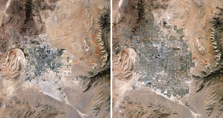
Las Vegas Expansion, 1989/2019. Source Imagery courtesy of The European Space Agency (ESA) Paris, France
Human impacts on Earth are a common issue nowadays, and many people say that there is no turning back. Climate crisis, greenhouse gases, exploitation of natural resources, production of solid waste and atmospheric pollution are some of the most pressing issues that the global community must address if we want to ensure a sound future for the next generations.
These topics can be viewed in full-color and high-definition in the new book Overview Timelapse: How We Change the Earth, by Benjamin Grant and Timothy Dougherty, which compiles 250 satellite and drone photographs of places on Earth that are in constant transformation.
Elche, Spain. Created by @dailyoverview, source imagery: @maxartechnologies
There is evidence that the orthogonal grid plan, which is one of the most common types of urban planning today, dates back to antiquity. Streets intersect at right angles to each other, resulting in a grid composed of streets, avenues, blocks, squares, parks, among other urban spaces.
The world's population is expected to reach 9.7 billion in 2050, an increase of 2 billion persons in the next 30 years.
As the world's population continues to increase, new challenges are expected to arise in addition to the aggravating issues already faced today. How will we live together? The theme of the Venice Biennale of Architecture, postponed to 2021, intends to instigate discussions and proposals concerning the role of architecture in times of increasing political differences, intolerance, and growing economic inequality.
Seeing the Earth from a great distance has been proven to stimulate awe, increase the desire to collaborate, and foster long-term thinking. Daily Overview aims to inspire these feelings — commonly referred to as the Overview Effect — through their imagery, products, and collaborations. By embracing the perspective that comes from this vantage point, the team believes they can stimulate a new awareness that will lead to a better future for our one and only home. Check out Daily Overview's Gallery of Amusement Parks and follow the team's work on their Instagram.