1. ArchDaily
  2. Ganges

Ganges: The Latest Architecture and News

Behind India's Ambitious Plan to Create the World's Longest River

Against the backdrop of an ever-increasing number of its farmers committing suicides, and its cities crumbling under intensifying pressure on their water resources—owing to their rapidly growing populations—India has revived its incredibly ambitious Interlinking of Rivers (ILR) project which aims to create a nation-wide water-grid twice the length of the Nile. The $168 billion project, first envisioned almost four decades ago, entails the linkage of thirty-seven of the country’s rivers through the construction of thirty canals and three-thousand water reservoirs. The chief objective is to address India’s regional inequity in water availability: 174 billion cubic meters of water is proposed to be transported across river basins, from potentially water-surplus to water-deficit areas.

The project is presented by the Indian government as the only realistic means to increase the country’s irrigation potential and per-capita water storage capacity. However, it raises ecological concerns of gargantuan proportions: 104,000 hectares of forest land will be affected, leading to the desecration of natural ecosystems. Experts in hydrology also question the scientific basis of treating rivers as “mere conduits of water.” Furthermore, the fear of large-scale involuntary human displacement—an estimated 1.5 million people—likely to be caused by the formation of water reservoirs is starting to materialize into a popular uprising.

Massive River Development Plan Hopes to Rejuvenate India's Relationship to the Ganges

Delhi-based firm Morphogenesis has recently unveiled a proposal for a project that will rehabilitate and develop the ghats (a flight of steps leading down to a river) and crematoriums along a 210-kilometer stretch of the Ganges, India’s longest river. The project, titled “A River in Need,” is part of the larger National Mission of Clean Ganga (NMCG), an undertaking of the Indian Government’s Ministry of Water Resources which was formed in 2011 with twin objectives: to ensure effective abatement of the river’s pollution and to conserve and rejuvenate it.

Massive River Development Plan Hopes to Rejuvenate India's Relationship to the Ganges - Image 4 of 4Massive River Development Plan Hopes to Rejuvenate India's Relationship to the Ganges - Image 9 of 4Massive River Development Plan Hopes to Rejuvenate India's Relationship to the Ganges - Image 18 of 4Massive River Development Plan Hopes to Rejuvenate India's Relationship to the Ganges - Image 20 of 4Massive River Development Plan Hopes to Rejuvenate India's Relationship to the Ganges - More Images+ 18

You Only Walk This Way Once: Anthony Acciavatti Interviewed by Vere van Gool

The following interview with Anthony Acciavatti was first published by Volume Magazine in their 48th issue, The Research Turn. You can read the Editorial of this issue, Research Horizons, here.

The Ganges River is India’s largest and most densely populated water basin. A lifeline to millions of people and carrying enormous celestial significance, the river is also severely polluted and suffers from dramatic droughts and floods. Vere van Gool spoke with Anthony Acciavatti to discuss the decade he spent navigating the Ganges and the new reading he was able to construct of this sacred river.

Vere van Gool: How did your journey begin?

Anthony Acciavatti: I’ve always been interested in the relationship between rivers and cities. It’s something of a romance really. I grew up not far from the Mississippi river and after doing some mappings of the Tiber river in relationship to the city of Rome, I came back to the States and finished my undergraduate thesis where I was looking at the Atchafalaya basin of south New Orleans, designing from the scale of mosquito habitats to the regional hydrodynamics of the Mississippi. While working on my thesis, I became very interested in looking into a large river system and noticed that the Ganges hadn't been mapped in about fifty years. All I could find were statistics attesting to its unprecedented levels of human density, agricultural production, and annual rainfall. So I wrote a Fulbright proposal in 2004, saying: if you give me a year, I will walk the land and create what I called a dynamic atlas of how the monsoon radically transforms this area every year.

Kumbh Mela: Designing the World's Largest Gathering Of People

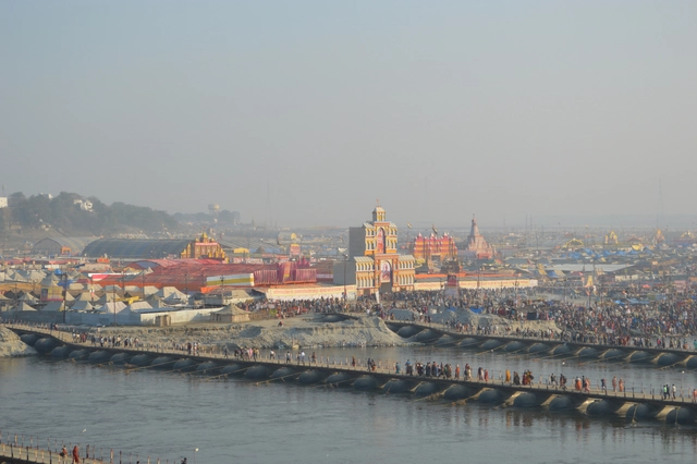
As the location of the world's largest single-purpose gathering of people, the 2013 Kumbh Mela obviously required a significant organizational effort from those charged with planning it - but what is less obvious is exactly how this need to plan can be squared with the nature of the Kumbh Mela itself. Located in the floodplain of the river Ganges, most of the 23.5-square-kilometer area of the festival (commonly referred to as the nagri) remains underwater until a few months before the festival, and organization is at every stage challenged by the uncertainty and ephemerality of the festival itself. In this excerpt from the recently published book, "Kumbh Mela, January 2013: Mapping the Ephemeral Mega City," Rahul Mehrotra, Chair of the Department of Urban Planning and Design at the Harvard GSD, and Felipe Vera, Co-director of the Center for Ecology, Landscape and Urbanism at UAI DesignLab, explain how infrastructure and street grids are deployed in a way that not only enables the Kumbh Mela festival itself, but enhances its ephemeral and democratic spirit.

Deployment Process

Standing at the Kumbh Mela at night looking towards an endless functioning city where the temporary construction of the nagri is fused with the city of Allahabad, there are two things that one cannot avoid asking: 1) How was this enormous city planned in terms of scale and complexity? 2) How is the city actually constructed? One of the most interesting elements about the construction process of the city is that unlike more static and permanent cities—where the whole is comprised of the aggregations of smaller parts, constructed in different moments that are tied together by pre-existing and connecting urban infrastructure—the city of the Kumbh Mela is planned and built all at once, as a unitary effort.