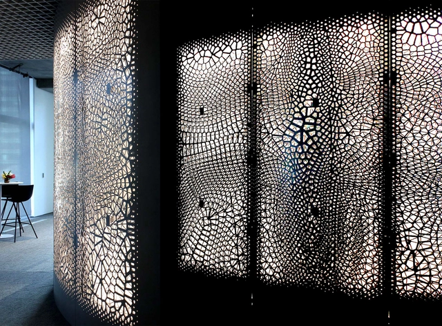
Responding in part to recent debates on how big data will affect our built environments, Synthesis Design + Architecture have teamed up with IBM Watson Analytics to design an interior feature wall for the Watson Experience Center in San Francisco. The project, named Data Moiré after the dizzying patterns created by overlapping sets of lines, uses data from the influence of mobile phones on monthly consumer spending to create a precise screen material that defines the wall.
On Thursday, December 22nd, an email arrived in the inboxes of ArchDaily’s editors that made us sit up, shake off our holiday-induced lethargy, and take notice. MASS Design Group’s Year in Review email might initially have blended in with the many other holiday wishes and 2016 recaps we receive at that time of year—it recapped such highlights as Michael Murphy’s TED Talk in February or the launch of the first African Design Center—but it had one thing that we hadn’t seen from other firm’s years-in-review: detailed statistics about the firm’s achievements that year.
In recent decades, certain aspects of architecture have become increasingly open to scientific analysis, most notably when it comes to a building’s environmental impact. It’s no surprise, therefore, to see MASS Design Group’s claims that their work uses 74% less embodied carbon than typical building projects, or that 78% of their materials are sourced within 100 kilometers, but alongside these were some more unusual metrics: since it was founded, the firm has invested 88% of construction costs regionally, created 15,765 jobs, and in 2016 alone, their work served a total of 64,580 users. These numbers suggest a way of thinking about architecture that few have attempted before—a way that, if widely adopted, could fundamentally change the way architecture is practiced and evaluated. We spoke to MASS co-founder Alan Ricks to find out how these statistics are calculated, and what purpose they serve.
Once a photograph is uploaded to social media, it ceases to be part of one’s private archive and becomes public property – as well as an object of study for researchers. There have been many attempts to study photographs on the scale of "Big Data." Take, for example, the numerous and well-publicised projects by Lev Manovich’s Big Data Lab. Evidently, using the results of one study of the huge online archive of photographs to make conclusions about society at large, is not necessarily a good idea. It’s fair to say that our society is not evenly represented online: a 19-year old woman may be posting her selfies daily, but it doesn’t mean that same goes for a sixty-five year old man. That said, we can learn a lot about cities and their inhabitants from the results of studies such as these.
Parallelism in Architecture, Environment And Computing Techniques, (PACT)
The theme of Parallelism in Architecture, Environment and Computing Techniques (PACT) 2016 explores the relations between computational design in architecture, organizational and global, ever-changing and pervasive contexts. PACT 2016 aims to gather practitioners and researchers interested in investigating and improving the state of practice of computational design software in the architectural discourse, where practicing design computing experts can explain the challenges they face in their day-to-day practices, and collectively induce an impact on the future of the field.
For a number of years now, Smart Cities and Big Data have been heralded as the future of urban design, taking advantage of our connected, technological world to make informed decisions on urban design and policy. But how can we make sure that we're collecting the best data? In this story, originally published on Autodesk's Redshift publication as "'Array' of Possibilities: Chicago’s New Wireless Sensor Networks to Create an Urban Internet of Things," Matt Alderton looks at a new initiative in Chicago to collect and publish data in a more comprehensive way than ever before.
If it hasn’t already, your daily routine will soon undergo a massive makeover.
For starters, when your alarm clock goes off, it will tell your coffeemaker to start brewing your morning joe. Then, when you’re on the way to work, your car will detect heavy traffic and send a text message to your boss, letting her know you’ll be late. When you arrive, you’ll print out the agenda for today’s staff meeting, at which point your printer will check how much ink it has left and automatically order its own replacement cartridges.
At lunch, you’ll think about dinner and use your smartphone to start the roast that’s waiting in your slow cooker at home. And when you come home a few hours later, your house will know you’re near, automatically turning on the lights, the heat, and the TV—channel changed to the evening news—prior to your arrival. It will be marvelous, and you’ll owe it all to the Internet of Things (IoT).
Videos
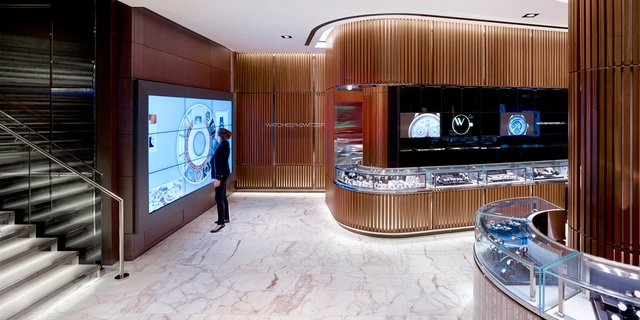
The new Watches of Switzerland store in London designed by Callison. Image Courtesy of Callison
With the rise of the internet, old-fashioned brick-and-mortar stores have struggled, as online ordering services have increasingly made it unnecessary to actually go to a store. The answer for the physical stores of the future? Make spaces not for purchasing the things people need, but experiencing the things people want, as explored in this article by Matt Alderton originally published on Autodesk's Redshift publication as "How Technology and Big Data in Retail Are Shaping Store Designs of the Future." Alderton looks at how forward-looking stores are being designed to appeal to customers, finding that the same technology revolution that threatened to make stores obsolete might also play a key role in saving them, too.
Shopping used to be stimulating. Although its end was sales, its means was a mix of status and spectacle. It was social commerce in which partakers transacted not just cash, but also cachet.
Nowhere was this more evident than in the earliest department stores, whose architects designed them to be destinations. In London, for instance, Harrods boasts the motto “Omnia, Omnibus, Ubique”—Latin for “All Things for All People, Everywhere.” Established in 1849, it has seven floors, comprising more than 1 million square feet across more than 330 departments. The store installed one of the world’s first escalators in 1898, opened a world-famous food hall in 1902, and sold exotic pets such as lion cubs until the 1970s.
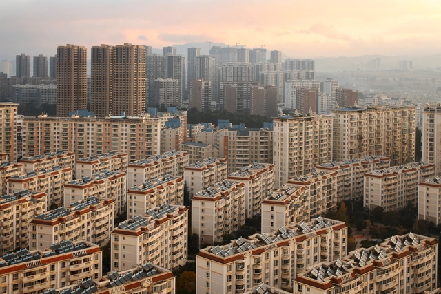
In recent decades, China has undergone the most dramatic urban migration in the history of the world, so you might be forgiven for thinking all that is required from urban planners is to "build it and they will come," so to speak. However, as the Western media often reports with much schadenfreude, China's unprecedented urban explosion has not come without a few missteps, and many new cities are widely claimed to be "ghost cities," empty of residents even as more gigantic apartment blocks are being built. Such stories are usually accompanied by anecdotes of empty public spaces and a rough count of the number of homes left in the dark at night, but little further empirical data. So exactly how underpopulated does a city have to be to be a "ghost city," and just how rife are such places in China?
As reported by MIT Technology Review, one Chinese web company has started looking for answers to just such questions. Baidu, effectively a Chinese version of Google, has used their "Big Data Lab" to investigate the commuting patterns of their 700 million users, establishing exactly which cities are dramatically underpopulated.
New York University’s Center for Urban Science and Progress has teamed up with the developers of Hudson Yards to transform the future 28-acre mixed-use neighborhood into the nations first “quantified community.” As Crain’s New York reports, the aim is to “use big data to make cities better places to live.” Information, from pedestrian traffic to energy production and resident activity levels, will be collected in order to study how cities can run efficiently and improve quality of living. You can read more on the subject, here.
Aerial of Amsterdam. Image Courtesy of Waag Society
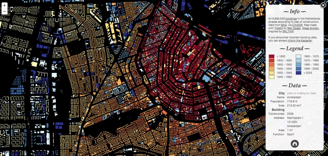
The Waag Society, together with designer and software engineer Bert Spaan, have put the Netherlands back on the map - the data map. After several months of coding and design, the partnership has managed to account for all 9,866,539 buildings in the country, visualized in varying colors to identify old and new buildings. After a user clicks on a specific block, additional building and city information displays square footages, addresses, populations and programs, among other stats. Users can navigate from Amsterdam to the Hague experiencing hundreds of years of urban development along the way, from the pre-1800s to post-2005 buildings, indicated by the red to blue gradient.
https://www.archdaily.com/424750/the-netherlands-software-engineers-create-data-map-of-all-buildingsJose Luis Gabriel Cruz